Safīpur geodata
Safīpur (Uttar Pradesh) is a populated place; located in India in Asia/Kolkata (GMT+5.5) time zone. With population of 24,801 people, there are 1717 cities with bigger population in this country. Compared to other cities in India, 76.2% of cities are located further ↓South; 70.5% of cities are located further ←West and 62.5% of cities have higher elevation than Safīpur. Note1


Safīpur GPS coordinates[2]
26° 44' 16.188" North, 80° 20' 36.6" East
| Map corner | latitude | longitude |
|---|---|---|
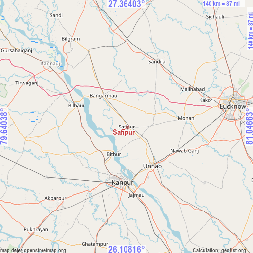
| Upper-left | 27.36403°, | 79.64038° |
| Center: | 26.73783°, | 80.3435° |
| Lower-right: | 26.10816°, | 81.04663° |
| Map W x H: | 139.6×139.6 km | = 86.7×86.7mi |
| max Lat: | 34.9274° ⇑23.8% North |
| Safīpur: | 26.73783° |
| min Lat: | ⇓76.2% South 8.09008° |
| min Long | Safīpur | max Long |
| 68.82655° | 80.3435° | 96.81° |
| W 70.5%⇐ | ⇒29.5% E |
Elevation
Elevation of Safīpur is 135 m = 443 ft, and this is 160.6 m = 527 ft below average elevation for this country.
| Max E: |
3681 m = 12077 ft | 62.5% |
| Avg. | 295.6 m = 970 ft | |
| Safīpur | 135 m = 443 ft | |
Min E: |
1 m = 3 ft | 37.5% |
See also: India elevation on elevation.city.
Geographical zone
Safīpur is located in North temperate zone (between Tropic of Cancer and the Arctic Circle). Distance of this Northern Tropic circle is 367 km =228 mi to South.| Distance of | km | miles | from Safīpur |
|---|---|---|---|
| North Pole | 7034.1 | 4370.8 | to North |
| Arctic Circle | 4428.2 | 2751.6 | to North |
| Tropic Cancer | 367 | 228 | to South |
| Equator | 2973 | 1847.3 | to South |


Nearby cities:
15 places around Safīpur: (largest is in red/bold)
• Aurās
25.5 km =15.8 mi,  39°
39°
• Bilhaur
30.1 km =18.7 mi,  292°
292°
• Bithūr
16.3 km =10.1 mi,  206°
206°
• Bāngarmau
21.5 km =13.4 mi,  322°
322°
• Fatehpur Chaurāsi
9.6 km =6 mi,  306°
306°
• Ganj Murādābād
29.1 km =18.1 mi,  327°
327°
• Jagdīshpur
20.1 km =12.5 mi,  86°
86°
• Kanpur
30.3 km =18.8 mi,  178°
178°
• Malīhābād
41.8 km =26 mi,  60°
60°
• Mohān
33.2 km =20.6 mi,  81°
81°
• Nawābganj
27 km =16.8 mi,  187°
187°
• Rasūlābād
14.6 km =9.1 mi, 86°
• Sandīla
40.6 km =25.2 mi,  24°
24°
• Ugu
6.9 km =4.3 mi,  341°
341°
• Unnāo
25.6 km =15.9 mi,  145°
145°
Sources, notices
• [Note1] Compared only with cities in India existing in our database
• [Src1] Map data: © OpenStreetMap contributors (CC-BY-SA)
• [Src2] Other city data from geonames.org with taken over terms of usage.
• [Src3] Geographical zone / Annual Mean Temperature by Robert A. Rohde @ Wikipedia
