Aurās geodata
Aurās (Uttar Pradesh) is a populated place; located in India in Asia/Kolkata (GMT+5.5) time zone. With population of 6,591 people, there are 3244 cities with bigger population in this country. Compared to other cities in India, 77.8% of cities are located further ↓South; 70.9% of cities are located further ←West and 63.2% of cities have higher elevation than Aurās. Note1


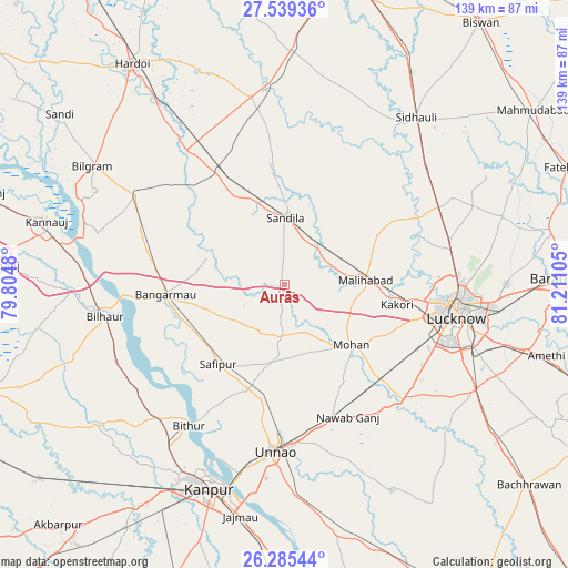
Aurās GPS coordinates[2]
26° 54' 50.904" North, 80° 30' 28.512" East
| Map corner | latitude | longitude |
|---|---|---|
| Upper-left | 27.53936°, | 79.8048° |
| Center: | 26.91414°, | 80.50792° |
| Lower-right: | 26.28544°, | 81.21105° |
| Map W x H: | 139.4×139.4 km | = 86.6×86.6mi |
| max Lat: | 34.9274° ⇑22.2% North |
| Aurās: | 26.91414° |
| min Lat: | ⇓77.8% South 8.09008° |
| min Long | Aurās | max Long |
| 68.82655° | 80.50792° | 96.81° |
| W 70.9%⇐ | ⇒29.1% E |
Elevation
Elevation of Aurās is 131 m = 430 ft, and this is 164.6 m = 540 ft below average elevation for this country.
| Max E: |
3681 m = 12077 ft | 63.2% |
| Avg. | 295.6 m = 970 ft | |
| Aurās | 131 m = 430 ft | |
Min E: |
1 m = 3 ft | 36.8% |
See also: India elevation on elevation.city.
Geographical zone
Aurās is located in North temperate zone (between Tropic of Cancer and the Arctic Circle). Distance of this Northern Tropic circle is 386.7 km =240.3 mi to South.| Distance of | km | miles | from Aurās |
|---|---|---|---|
| North Pole | 7014.5 | 4358.6 | to North |
| Arctic Circle | 4408.6 | 2739.4 | to North |
| Tropic Cancer | 386.7 | 240.3 | to South |
| Equator | 2992.6 | 1859.5 | to South |


Nearby cities:
15 places around Aurās: (largest is in red/bold)
• Benīganj
42.6 km =26.5 mi,  351°
351°
• Bithūr
41.5 km =25.8 mi,  214°
214°
• Bāngarmau
29.5 km =18.3 mi,  265°
265°
• Fatehpur Chaurāsi
27.8 km =17.3 mi,  239°
239°
• Ganj Murādābād
32.5 km =20.2 mi,  278°
278°
• Jagdīshpur
18.7 km =11.6 mi,  168°
168°
• Kākori
28 km =17.4 mi,  100°
100°
• Lucknow
42 km =26.1 mi, 101°
• Malīhābād
20.1 km =12.5 mi,  87°
87°
• Mohān
22.3 km =13.9 mi,  131°
131°
• Rasūlābād
18.9 km =11.7 mi,  185°
185°
• Safīpur
25.5 km =15.8 mi,  219°
219°
• Sandīla
17.3 km =10.7 mi,  2°
2°
• Ugu
22.7 km =14.1 mi,  234°
234°
• Unnāo
40.9 km =25.4 mi,  182°
182°
Sources, notices
• [Note1] Compared only with cities in India existing in our database
• [Src1] Map data: © OpenStreetMap contributors (CC-BY-SA)
• [Src2] Other city data from geonames.org with taken over terms of usage.
• [Src3] Geographical zone / Annual Mean Temperature by Robert A. Rohde @ Wikipedia
