Ganj Murādābād geodata
Ganj Murādābād (Uttar Pradesh) is a populated place; located in India in Asia/Kolkata (GMT+5.5) time zone. With population of 9,970 people, there are 2950 cities with bigger population in this country. Compared to other cities in India, 78.1% of cities are located further ↓South; 69.4% of cities are located further ←West and 62.1% of cities have higher elevation than Ganj Murādābād. Note1


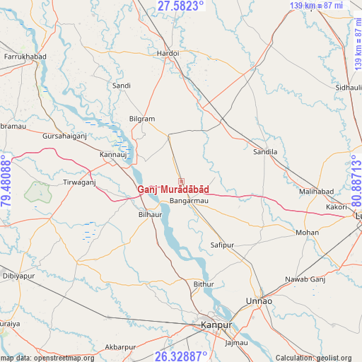
Ganj Murādābād GPS coordinates[2]
26° 57' 26.388" North, 80° 11' 2.4" East
| Map corner | latitude | longitude |
|---|---|---|
| Upper-left | 27.5823°, | 79.48088° |
| Center: | 26.95733°, | 80.184° |
| Lower-right: | 26.32887°, | 80.88713° |
| Map W x H: | 139.4×139.4 km | = 86.6×86.6mi |
| max Lat: | 34.9274° ⇑21.9% North |
| Ganj Murādābād: | 26.95733° |
| min Lat: | ⇓78.1% South 8.09008° |
| min Long | Ganj Murādāb� | max Long |
| 68.82655° | 80.184° | 96.81° |
| W 69.4%⇐ | ⇒30.6% E |
Elevation
Elevation of Ganj Murādābād is 137 m = 449 ft, and this is 158.6 m = 520 ft below average elevation for this country.
| Max E: |
3681 m = 12077 ft | 62.1% |
| Avg. | 295.6 m = 970 ft | |
| Ganj Murādābād | 137 m = 449 ft | |
Min E: |
1 m = 3 ft | 37.9% |
See also: India elevation on elevation.city.
Geographical zone
Ganj Murādābād is located in North temperate zone (between Tropic of Cancer and the Arctic Circle). Distance of this Northern Tropic circle is 391.5 km =243.3 mi to South.| Distance of | km | miles | from Ganj Murādābād |
|---|---|---|---|
| North Pole | 7009.7 | 4355.6 | to North |
| Arctic Circle | 4403.8 | 2736.4 | to North |
| Tropic Cancer | 391.5 | 243.3 | to South |
| Equator | 2997.4 | 1862.5 | to South |


Nearby cities:
15 places around Ganj Murādābād: (largest is in red/bold)
• Aurās
32.5 km =20.2 mi,  98°
98°
• Benīganj
45.3 km =28.1 mi,  34°
34°
• Bilgrām
28.5 km =17.7 mi,  328°
328°
• Bilhaur
17.4 km =10.8 mi,  223°
223°
• Bithūr
39.9 km =24.8 mi,  167°
167°
• Bāngarmau
7.8 km =4.8 mi,  159°
159°
• Fatehpur Chaurāsi
20.4 km =12.7 mi, 156°
• Jagdīshpur
42.6 km =26.5 mi,  122°
122°
• Kannauj
28.4 km =17.6 mi,  292°
292°
• Mādhoganj
18.4 km =11.4 mi,  346°
346°
• Rasūlābād
38.5 km =23.9 mi,  127°
127°
• Safīpur
29.1 km =18.1 mi,  147°
147°
• Sandīla
35.1 km =21.8 mi,  69°
69°
• Sāndi
43.4 km =27 mi, 328°
• Ugu
22.4 km =13.9 mi,  142°
142°
Sources, notices
• [Note1] Compared only with cities in India existing in our database
• [Src1] Map data: © OpenStreetMap contributors (CC-BY-SA)
• [Src2] Other city data from geonames.org with taken over terms of usage.
• [Src3] Geographical zone / Annual Mean Temperature by Robert A. Rohde @ Wikipedia
