Fatehpur Chaurāsi geodata
Fatehpur Chaurāsi (Uttar Pradesh) is a populated place; located in India in Asia/Kolkata (GMT+5.5) time zone. With population of 5,931 people, there are 3295 cities with bigger population in this country. Compared to other cities in India, 76.8% of cities are located further ↓South; 70.1% of cities are located further ←West and 63.4% of cities have higher elevation than Fatehpur Chaurāsi. Note1


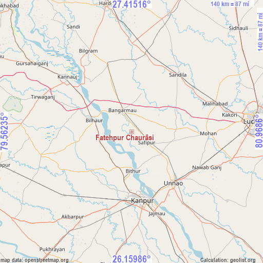
Fatehpur Chaurāsi GPS coordinates[2]
26° 47' 21.3" North, 80° 15' 55.692" East
| Map corner | latitude | longitude |
|---|---|---|
| Upper-left | 27.41516°, | 79.56235° |
| Center: | 26.78925°, | 80.26547° |
| Lower-right: | 26.15986°, | 80.9686° |
| Map W x H: | 139.6×139.6 km | = 86.7×86.7mi |
| max Lat: | 34.9274° ⇑23.2% North |
| Fatehpur Chaurāsi: | 26.78925° |
| min Lat: | ⇓76.8% South 8.09008° |
| min Long | Fatehpur Chaur� | max Long |
| 68.82655° | 80.26547° | 96.81° |
| W 70.1%⇐ | ⇒29.9% E |
Elevation
Elevation of Fatehpur Chaurāsi is 130 m = 427 ft, and this is 165.6 m = 543 ft below average elevation for this country.
| Max E: |
3681 m = 12077 ft | 63.4% |
| Avg. | 295.6 m = 970 ft | |
| Fatehpur Chaurāsi | 130 m = 427 ft | |
Min E: |
1 m = 3 ft | 36.6% |
See also: India elevation on elevation.city.
Geographical zone
Fatehpur Chaurāsi is located in North temperate zone (between Tropic of Cancer and the Arctic Circle). Distance of this Northern Tropic circle is 372.8 km =231.6 mi to South.| Distance of | km | miles | from Fatehpur Chaurāsi |
|---|---|---|---|
| North Pole | 7028.4 | 4367.2 | to North |
| Arctic Circle | 4422.5 | 2748 | to North |
| Tropic Cancer | 372.8 | 231.6 | to South |
| Equator | 2978.7 | 1850.9 | to South |


Nearby cities:
15 places around Fatehpur Chaurāsi: (largest is in red/bold)
• Aurās
27.8 km =17.3 mi,  59°
59°
• Bilhaur
20.9 km =13 mi,  286°
286°
• Bithūr
20.3 km =12.6 mi,  178°
178°
• Bāngarmau
12.5 km =7.8 mi,  334°
334°
• Ganj Murādābād
20.4 km =12.7 mi,  336°
336°
• Jagdīshpur
28.1 km =17.5 mi,  99°
99°
• Kanpur
37 km =23 mi,  166°
166°
• Mohān
40.7 km =25.3 mi,  91°
91°
• Mādhoganj
38.6 km =24 mi, 341°
• Nawābganj
32.8 km =20.4 mi, 172°
• Rasūlābād
22.8 km =14.2 mi, 102°
• Safīpur
9.6 km =6 mi,  126°
126°
• Sandīla
39.8 km =24.7 mi,  38°
38°
• Ugu
5.6 km =3.5 mi,  81°
81°
• Unnāo
34.8 km =21.6 mi,  140°
140°
Sources, notices
• [Note1] Compared only with cities in India existing in our database
• [Src1] Map data: © OpenStreetMap contributors (CC-BY-SA)
• [Src2] Other city data from geonames.org with taken over terms of usage.
• [Src3] Geographical zone / Annual Mean Temperature by Robert A. Rohde @ Wikipedia
