Ugu geodata
Ugu (Uttar Pradesh) is a populated place; located in India in Asia/Kolkata (GMT+5.5) time zone. With population of 6,518 people, there are 3247 cities with bigger population in this country. Compared to other cities in India, 76.9% of cities are located further ↓South; 70.4% of cities are located further ←West and 62.7% of cities have higher elevation than Ugu. Note1


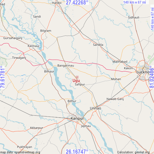
Ugu GPS coordinates[2]
26° 47' 48.516" North, 80° 19' 15.348" East
| Map corner | latitude | longitude |
|---|---|---|
| Upper-left | 27.42268°, | 79.61781° |
| Center: | 26.79681°, | 80.32093° |
| Lower-right: | 26.16747°, | 81.02406° |
| Map W x H: | 139.6×139.6 km | = 86.7×86.7mi |
| max Lat: | 34.9274° ⇑23.1% North |
| Ugu: | 26.79681° |
| min Lat: | ⇓76.9% South 8.09008° |
| min Long | Ugu | max Long |
| 68.82655° | 80.32093° | 96.81° |
| W 70.4%⇐ | ⇒29.6% E |
Elevation
Elevation of Ugu is 134 m = 440 ft, and this is 161.6 m = 530 ft below average elevation for this country.
| Max E: |
3681 m = 12077 ft | 62.7% |
| Avg. | 295.6 m = 970 ft | |
| Ugu | 134 m = 440 ft | |
Min E: |
1 m = 3 ft | 37.3% |
See also: India elevation on elevation.city.
Geographical zone
Ugu is located in North temperate zone (between Tropic of Cancer and the Arctic Circle). Distance of this Northern Tropic circle is 373.6 km =232.1 mi to South.| Distance of | km | miles | from Ugu |
|---|---|---|---|
| North Pole | 7027.5 | 4366.7 | to North |
| Arctic Circle | 4421.6 | 2747.5 | to North |
| Tropic Cancer | 373.6 | 232.1 | to South |
| Equator | 2979.5 | 1851.4 | to South |


Nearby cities:
15 places around Ugu: (largest is in red/bold)
• Aurās
22.7 km =14.1 mi,  54°
54°
• Bilhaur
26 km =16.2 mi,  281°
281°
• Bithūr
21.7 km =13.5 mi,  193°
193°
• Bāngarmau
15.1 km =9.4 mi,  314°
314°
• Fatehpur Chaurāsi
5.6 km =3.5 mi,  261°
261°
• Ganj Murādābād
22.4 km =13.9 mi,  322°
322°
• Jagdīshpur
22.9 km =14.2 mi,  103°
103°
• Kanpur
37 km =23 mi,  175°
175°
• Mohān
35.2 km =21.9 mi,  93°
93°
• Mādhoganj
39.9 km =24.8 mi,  333°
333°
• Nawābganj
33.3 km =20.7 mi, 181°
• Rasūlābād
17.8 km =11.1 mi,  108°
108°
• Safīpur
6.9 km =4.3 mi,  161°
161°
• Sandīla
35.9 km =22.3 mi,  32°
32°
• Unnāo
32.3 km =20.1 mi,  149°
149°
Sources, notices
• [Note1] Compared only with cities in India existing in our database
• [Src1] Map data: © OpenStreetMap contributors (CC-BY-SA)
• [Src2] Other city data from geonames.org with taken over terms of usage.
• [Src3] Geographical zone / Annual Mean Temperature by Robert A. Rohde @ Wikipedia
