Mānsa geodata
Mānsa (Punjab) is a populated place; located in India in Asia/Kolkata (GMT+5.5) time zone. With population of 80,018 people, there are 546 cities with bigger population in this country. Compared to other cities in India, 92.8% of cities are located further ↓South; 79.1% of cities are located further →East and 54.2% of cities have lower elevation than Mānsa. Note1


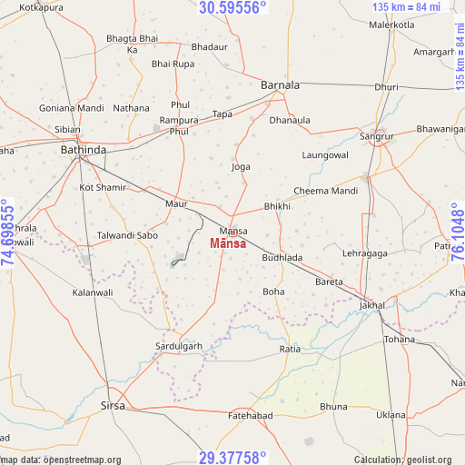
Mānsa GPS coordinates[2]
29° 59' 18.384" North, 75° 24' 6.012" East
| Map corner | latitude | longitude |
|---|---|---|
| Upper-left | 30.59556°, | 74.69855° |
| Center: | 29.98844°, | 75.40167° |
| Lower-right: | 29.37758°, | 76.1048° |
| Map W x H: | 135.4×135.4 km | = 84.1×84.1mi |
| max Lat: | 34.9274° ⇑7.2% North |
| Mānsa: | 29.98844° |
| min Lat: | ⇓92.8% South 8.09008° |
| min Long | Mānsa | max Long |
| 68.82655° | 75.40167° | 96.81° |
| W 20.9%⇐ | ⇒79.1% E |
Elevation
Elevation of Mānsa is 223 m = 732 ft, and this is 72.6 m = 238 ft below average elevation for this country.
| Max E: |
3681 m = 12077 ft | 45.8% |
| Avg. | 295.6 m = 970 ft | |
| Mānsa | 223 m = 732 ft | |
Min E: |
1 m = 3 ft | 54.2% |
See also: Mānsa elevation on elevation.city.
Geographical zone
Mānsa is located in North temperate zone (between Tropic of Cancer and the Arctic Circle). Distance of this Northern Tropic circle is 728.5 km =452.7 mi to South.| Distance of | km | miles | from Mānsa |
|---|---|---|---|
| North Pole | 6672.7 | 4146.2 | to North |
| Arctic Circle | 4066.8 | 2527 | to North |
| Tropic Cancer | 728.5 | 452.7 | to South |
| Equator | 3334.4 | 2071.9 | to South |


Nearby cities:
15 places around Mānsa: (largest is in red/bold)
• Akālgarh
50.7 km =31.5 mi,  111°
111°
• Barnāla
45.2 km =28.1 mi,  18°
18°
• Bathinda
50.7 km =31.5 mi,  298°
298°
• Bhīkhi
15.1 km =9.4 mi,  58°
58°
• Budhlāda
16.8 km =10.4 mi, 113°
• Dhanaula
36.6 km =22.7 mi,  26°
26°
• Jākhal
46 km =28.6 mi,  117°
117°
• Kālānwāli
44.8 km =27.8 mi,  247°
247°
• Laungowāl
35.3 km =21.9 mi,  49°
49°
• Maur
18 km =11.2 mi,  305°
305°
• Ratia
37.2 km =23.1 mi,  152°
152°
• Rāmpura
33.5 km =20.8 mi,  332°
332°
• Sangrūr
51.3 km =31.9 mi, 56°
• Sardulgarh
36.6 km =22.7 mi,  205°
205°
• Sunām
41.3 km =25.7 mi,  67°
67°
Sources, notices
• [Note1] Compared only with cities in India existing in our database
• [Src1] Map data: © OpenStreetMap contributors (CC-BY-SA)
• [Src2] Other city data from geonames.org with taken over terms of usage.
• [Src3] Geographical zone / Annual Mean Temperature by Robert A. Rohde @ Wikipedia
