Maur geodata
Maur (Punjab) is a populated place; located in India in Asia/Kolkata (GMT+5.5) time zone. With population of 28,295 people, there are 1524 cities with bigger population in this country. Compared to other cities in India, 93% of cities are located further ↓South; 80.5% of cities are located further →East and 53.6% of cities have lower elevation than Maur. Note1


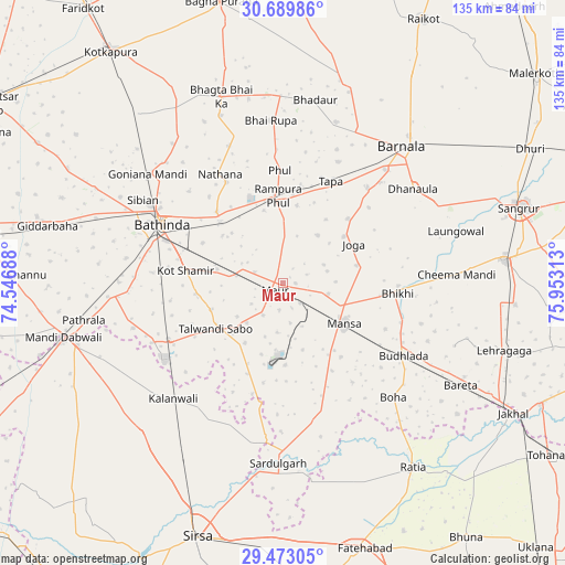
Maur GPS coordinates[2]
30° 4' 59.988" North, 75° 15' 0" East
| Map corner | latitude | longitude |
|---|---|---|
| Upper-left | 30.68986°, | 74.54688° |
| Center: | 30.08333°, | 75.25° |
| Lower-right: | 29.47305°, | 75.95313° |
| Map W x H: | 135.3×135.3 km | = 84.1×84.1mi |
| max Lat: | 34.9274° ⇑7% North |
| Maur: | 30.08333° |
| min Lat: | ⇓93% South 8.09008° |
| min Long | Maur | max Long |
| 68.82655° | 75.25° | 96.81° |
| W 19.5%⇐ | ⇒80.5% E |
Elevation
Elevation of Maur is 220 m = 722 ft, and this is 75.6 m = 248 ft below average elevation for this country.
| Max E: |
3681 m = 12077 ft | 46.4% |
| Avg. | 295.6 m = 970 ft | |
| Maur | 220 m = 722 ft | |
Min E: |
1 m = 3 ft | 53.6% |
See also: India elevation on elevation.city.
Geographical zone
Maur is located in North temperate zone (between Tropic of Cancer and the Arctic Circle). Distance of this Northern Tropic circle is 739 km =459.2 mi to South.| Distance of | km | miles | from Maur |
|---|---|---|---|
| North Pole | 6662.1 | 4139.6 | to North |
| Arctic Circle | 4056.2 | 2520.4 | to North |
| Tropic Cancer | 739 | 459.2 | to South |
| Equator | 3345 | 2078.5 | to South |


Nearby cities:
15 places around Maur: (largest is in red/bold)
• Barnāla
43.3 km =26.9 mi,  41°
41°
• Bathinda
32.9 km =20.4 mi,  294°
294°
• Bhadaur
44.4 km =27.6 mi,  10°
10°
• Bhīkhi
27.6 km =17.1 mi,  95°
95°
• Budhlāda
34.7 km =21.6 mi,  119°
119°
• Dabwāli
51.5 km =32 mi,  253°
253°
• Dhanaula
38.1 km =23.7 mi,  54°
54°
• Jaito
53.4 km =33.2 mi,  319°
319°
• Kālānwāli
38.4 km =23.9 mi,  224°
224°
• Laungowāl
43.2 km =26.8 mi,  73°
73°
• Mānsa
18 km =11.2 mi,  125°
125°
• Ratia
53.9 km =33.5 mi,  144°
144°
• Rāmpura
19.2 km =11.9 mi,  357°
357°
• Sardulgarh
43.5 km =27 mi,  181°
181°
• Sunām
53.1 km =33 mi,  84°
84°
Sources, notices
• [Note1] Compared only with cities in India existing in our database
• [Src1] Map data: © OpenStreetMap contributors (CC-BY-SA)
• [Src2] Other city data from geonames.org with taken over terms of usage.
• [Src3] Geographical zone / Annual Mean Temperature by Robert A. Rohde @ Wikipedia
