Sardulgarh geodata
Sardulgarh (Punjab) is a populated place; located in India in Asia/Kolkata (GMT+5.5) time zone. With population of 17,270 people, there are 2259 cities with bigger population in this country. Compared to other cities in India, 91.8% of cities are located further ↓South; 80.7% of cities are located further →East and 51.9% of cities have lower elevation than Sardulgarh. Note1


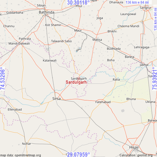
Sardulgarh GPS coordinates[2]
29° 41' 32.064" North, 75° 14' 9.888" East
| Map corner | latitude | longitude |
|---|---|---|
| Upper-left | 30.30118°, | 74.53296° |
| Center: | 29.69224°, | 75.23608° |
| Lower-right: | 29.07959°, | 75.93921° |
| Map W x H: | 135.8×135.8 km | = 84.4×84.4mi |
| max Lat: | 34.9274° ⇑8.2% North |
| Sardulgarh: | 29.69224° |
| min Lat: | ⇓91.8% South 8.09008° |
| min Long | Sardulgarh | max Long |
| 68.82655° | 75.23608° | 96.81° |
| W 19.3%⇐ | ⇒80.7% E |
Elevation
Elevation of Sardulgarh is 213 m = 699 ft, and this is 82.6 m = 271 ft below average elevation for this country.
| Max E: |
3681 m = 12077 ft | 48.1% |
| Avg. | 295.6 m = 970 ft | |
| Sardulgarh | 213 m = 699 ft | |
Min E: |
1 m = 3 ft | 51.9% |
See also: India elevation on elevation.city.
Geographical zone
Sardulgarh is located in North temperate zone (between Tropic of Cancer and the Arctic Circle). Distance of this Northern Tropic circle is 695.5 km =432.2 mi to South.| Distance of | km | miles | from Sardulgarh |
|---|---|---|---|
| North Pole | 6705.6 | 4166.7 | to North |
| Arctic Circle | 4099.7 | 2547.4 | to North |
| Tropic Cancer | 695.5 | 432.2 | to South |
| Equator | 3301.5 | 2051.5 | to South |


Nearby cities:
15 places around Sardulgarh: (largest is in red/bold)
• Bhīkhi
50 km =31.1 mi,  35°
35°
• Budhlāda
40.9 km =25.4 mi,  50°
50°
• Dabwāli
55.9 km =34.7 mi,  300°
300°
• Ellenabad
61.6 km =38.3 mi,  244°
244°
• Fatehābād
28.9 km =18 mi,  132°
132°
• Gorakhpur
50.2 km =31.2 mi,  122°
122°
• Inda Chhoi
53.9 km =33.5 mi,  96°
96°
• Jākhal
57.9 km =36 mi,  78°
78°
• Kālānwāli
30.1 km =18.7 mi, 302°
• Maur
43.5 km =27 mi,  1°
1°
• Mānsa
36.6 km =22.7 mi,  25°
25°
• Ratia
32.9 km =20.4 mi,  90°
90°
• Rāmpura
62.7 km =39 mi, 0°
• Rānia
42.9 km =26.7 mi, 244°
• Sirsa
26.6 km =16.5 mi,  228°
228°
Sources, notices
• [Note1] Compared only with cities in India existing in our database
• [Src1] Map data: © OpenStreetMap contributors (CC-BY-SA)
• [Src2] Other city data from geonames.org with taken over terms of usage.
• [Src3] Geographical zone / Annual Mean Temperature by Robert A. Rohde @ Wikipedia
