Rājula geodata
Rājula (Gujarat) is a populated place; located in India in Asia/Kolkata (GMT+5.5) time zone. With population of 34,652 people, there are 1252 cities with bigger population in this country. Compared to other cities in India, 61.5% of cities are located further ↑North; 98.1% of cities are located further →East and 80.2% of cities have higher elevation than Rājula. Note1


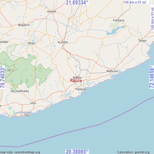
Rājula GPS coordinates[2]
21° 2' 18.744" North, 71° 26' 36.42" East
| Map corner | latitude | longitude |
|---|---|---|
| Upper-left | 21.69334°, | 70.74033° |
| Center: | 21.03854°, | 71.44345° |
| Lower-right: | 20.38085°, | 72.14658° |
| Map W x H: | 145.9×145.9 km | = 90.7×90.7mi |
| max Lat: | 34.9274° ⇑61.5% North |
| Rājula: | 21.03854° |
| min Lat: | ⇓38.5% South 8.09008° |
| min Long | Rājula | max Long |
| 68.82655° | 71.44345° | 96.81° |
| W 1.9%⇐ | ⇒98.1% E |
Elevation
Elevation of Rājula is 47 m = 154 ft, and this is 248.6 m = 816 ft below average elevation for this country.
| Max E: |
3681 m = 12077 ft | 80.2% |
| Avg. | 295.6 m = 970 ft | |
| Rājula | 47 m = 154 ft | |
Min E: |
1 m = 3 ft | 19.8% |
See also: India elevation on elevation.city.
Geographical zone
Rājula is located in North Torrid zone (between Equator and Tropic of Cancer). Distance of this Northern Tropic circle is 266.7 km =165.7 mi to North.| Distance of | km | miles | from Rājula |
|---|---|---|---|
| North Pole | 7667.8 | 4764.5 | to North |
| Arctic Circle | 5061.9 | 3145.3 | to North |
| Tropic Cancer | 266.7 | 165.7 | to North |
| Equator | 2339.3 | 1453.6 | to South |


Nearby cities:
15 places around Rājula: (largest is in red/bold)
• Amreli
66.9 km =41.6 mi,  338°
338°
• Bagasra
71.1 km =44.2 mi,  314°
314°
• Chalāla
50.4 km =31.3 mi,  325°
325°
• Delvāda
50.6 km =31.4 mi,  234°
234°
• Dhāri
53.9 km =33.5 mi, 306°
• Diu
60 km =37.3 mi, 233°
• Dungarpur
42.6 km =26.5 mi,  49°
49°
• Dāmnagar
73.1 km =45.4 mi,  6°
6°
• Gariadhar
57.3 km =35.6 mi, 14°
• Katpur
36.5 km =22.7 mi,  86°
86°
• Kundla
36.6 km =22.7 mi, 337°
• Pālitāna
66.9 km =41.6 mi,  36°
36°
• Savarkundla
36.2 km =22.5 mi, 336°
• Talāja
70.6 km =43.9 mi,  60°
60°
• Una
48.4 km =30.1 mi,  240°
240°
Sources, notices
• [Note1] Compared only with cities in India existing in our database
• [Src1] Map data: © OpenStreetMap contributors (CC-BY-SA)
• [Src2] Other city data from geonames.org with taken over terms of usage.
• [Src3] Geographical zone / Annual Mean Temperature by Robert A. Rohde @ Wikipedia
