Talāja geodata
Talāja (Gujarat) is a populated place; located in India in Asia/Kolkata (GMT+5.5) time zone. With population of 29,948 people, there are 1447 cities with bigger population in this country. Compared to other cities in India, 59.7% of cities are located further ↑North; 97.3% of cities are located further →East and 86.8% of cities have higher elevation than Talāja. Note1


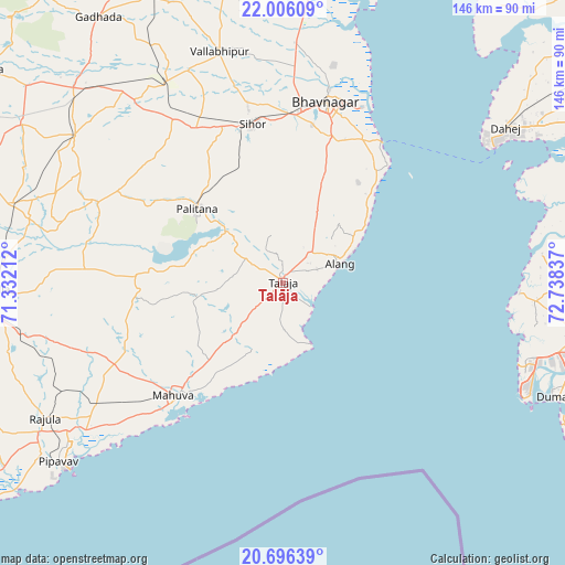
Talāja GPS coordinates[2]
21° 21' 9.72" North, 72° 2' 6.864" East
| Map corner | latitude | longitude |
|---|---|---|
| Upper-left | 22.00609°, | 71.33212° |
| Center: | 21.3527°, | 72.03524° |
| Lower-right: | 20.69639°, | 72.73837° |
| Map W x H: | 145.6×145.6 km | = 90.5×90.5mi |
| max Lat: | 34.9274° ⇑59.7% North |
| Talāja: | 21.3527° |
| min Lat: | ⇓40.3% South 8.09008° |
| min Long | Talāja | max Long |
| 68.82655° | 72.03524° | 96.81° |
| W 2.7%⇐ | ⇒97.3% E |
Elevation
Elevation of Talāja is 25 m = 82 ft, and this is 270.6 m = 888 ft below average elevation for this country.
| Max E: |
3681 m = 12077 ft | 86.8% |
| Avg. | 295.6 m = 970 ft | |
| Talāja | 25 m = 82 ft | |
Min E: |
1 m = 3 ft | 13.2% |
See also: India elevation on elevation.city.
Geographical zone
Talāja is located in North Torrid zone (between Equator and Tropic of Cancer). Distance of this Northern Tropic circle is 231.7 km =144 mi to North.| Distance of | km | miles | from Talāja |
|---|---|---|---|
| North Pole | 7632.9 | 4742.9 | to North |
| Arctic Circle | 5027 | 3123.6 | to North |
| Tropic Cancer | 231.7 | 144 | to North |
| Equator | 2374.2 | 1475.3 | to South |


Nearby cities:
15 places around Talāja: (largest is in red/bold)
• Bhavnagar
47.2 km =29.3 mi,  14°
14°
• Dhola
64.7 km =40.2 mi,  335°
335°
• Dungarpur
29.9 km =18.6 mi,  256°
256°
• Dāmnagar
65.5 km =40.7 mi,  305°
305°
• Gariadhar
51.7 km =32.1 mi,  293°
293°
• Ghogha
44.9 km =27.9 mi,  33°
33°
• Katpur
41.1 km =25.5 mi,  217°
217°
• Kundla
75.5 km =46.9 mi,  269°
269°
• Olpād
74.2 km =46.1 mi,  91°
91°
• Pālitāna
29.2 km =18.1 mi, 311°
• Rājula
70.6 km =43.9 mi,  240°
240°
• Sihor
40.6 km =25.2 mi,  349°
349°
• Umrāla
59.6 km =37 mi, 336°
• Valabhīpur
61.7 km =38.3 mi, 344°
• Vartej
43.1 km =26.8 mi,  4°
4°
Sources, notices
• [Note1] Compared only with cities in India existing in our database
• [Src1] Map data: © OpenStreetMap contributors (CC-BY-SA)
• [Src2] Other city data from geonames.org with taken over terms of usage.
• [Src3] Geographical zone / Annual Mean Temperature by Robert A. Rohde @ Wikipedia
