Diu geodata
Diu (Daman and Diu) is a populated place; located in India in Asia/Kolkata (GMT+5.5) time zone. With population of 23,779 people, there are 1785 cities with bigger population in this country. Compared to other cities in India, 63% of cities are located further ↑North; 98.5% of cities are located further →East and 90.4% of cities have higher elevation than Diu. Note1


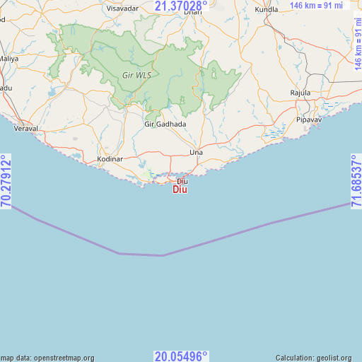
Diu GPS coordinates[2]
20° 42' 50.58" North, 70° 58' 56.064" East
| Map corner | latitude | longitude |
|---|---|---|
| Upper-left | 21.37028°, | 70.27912° |
| Center: | 20.71405°, | 70.98224° |
| Lower-right: | 20.05496°, | 71.68537° |
| Map W x H: | 146.2×146.3 km | = 90.8×90.9mi |
| max Lat: | 34.9274° ⇑63% North |
| Diu: | 20.71405° |
| min Lat: | ⇓37% South 8.09008° |
| min Long | Diu | max Long |
| 68.82655° | 70.98224° | 96.81° |
| W 1.5%⇐ | ⇒98.5% E |
Elevation
Elevation of Diu is 17 m = 56 ft, and this is 278.6 m = 914 ft below average elevation for this country.
| Max E: |
3681 m = 12077 ft | 90.4% |
| Avg. | 295.6 m = 970 ft | |
| Diu | 17 m = 56 ft | |
Min E: |
1 m = 3 ft | 9.6% |
See also: India elevation on elevation.city.
Geographical zone
Diu is located in North Torrid zone (between Equator and Tropic of Cancer). Distance of this Northern Tropic circle is 302.7 km =188.1 mi to North.| Distance of | km | miles | from Diu |
|---|---|---|---|
| North Pole | 7703.9 | 4787 | to North |
| Arctic Circle | 5098 | 3167.7 | to North |
| Tropic Cancer | 302.7 | 188.1 | to North |
| Equator | 2303.2 | 1431.1 | to South |


Nearby cities:
15 places around Diu: (largest is in red/bold)
• Bagasra
86 km =53.4 mi,  358°
358°
• Bilkha
90.1 km =56 mi,  333°
333°
• Chalāla
79.8 km =49.6 mi,  13°
13°
• Delvāda
9.5 km =5.9 mi,  44°
44°
• Dhāri
68.5 km =42.6 mi,  3°
3°
• Katpur
92.7 km =57.6 mi,  65°
65°
• Keshod
100.5 km =62.4 mi,  310°
310°
• Kodīnar
30.4 km =18.9 mi,  286°
286°
• Kundla
77.5 km =48.2 mi,  25°
25°
• Mendarda
87.8 km =54.6 mi,  320°
320°
• Rājula
60 km =37.3 mi,  53°
53°
• Savarkundla
76.9 km =47.8 mi, 25°
• Una
13.4 km =8.3 mi, 25°
• Verāval
67.4 km =41.9 mi, 288°
• Vīsāvadar
73.6 km =45.7 mi,  340°
340°
Sources, notices
• [Note1] Compared only with cities in India existing in our database
• [Src1] Map data: © OpenStreetMap contributors (CC-BY-SA)
• [Src2] Other city data from geonames.org with taken over terms of usage.
• [Src3] Geographical zone / Annual Mean Temperature by Robert A. Rohde @ Wikipedia
