Una geodata
Una (Gujarat) is a populated place; located in India in Asia/Kolkata (GMT+5.5) time zone. With population of 56,545 people, there are 783 cities with bigger population in this country. Compared to other cities in India, 62.4% of cities are located further ↑North; 98.5% of cities are located further →East and 85.5% of cities have higher elevation than Una. Note1


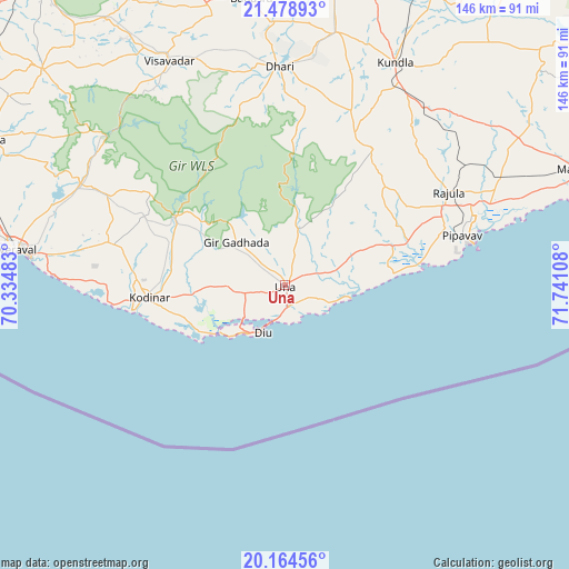
Una GPS coordinates[2]
20° 49' 23.448" North, 71° 2' 16.62" East
| Map corner | latitude | longitude |
|---|---|---|
| Upper-left | 21.47893°, | 70.33483° |
| Center: | 20.82318°, | 71.03795° |
| Lower-right: | 20.16456°, | 71.74108° |
| Map W x H: | 146.1×146.1 km | = 90.8×90.8mi |
| max Lat: | 34.9274° ⇑62.4% North |
| Una: | 20.82318° |
| min Lat: | ⇓37.6% South 8.09008° |
| min Long | Una | max Long |
| 68.82655° | 71.03795° | 96.81° |
| W 1.5%⇐ | ⇒98.5% E |
Elevation
Elevation of Una is 29 m = 95 ft, and this is 266.6 m = 875 ft below average elevation for this country.
| Max E: |
3681 m = 12077 ft | 85.5% |
| Avg. | 295.6 m = 970 ft | |
| Una | 29 m = 95 ft | |
Min E: |
1 m = 3 ft | 14.5% |
See also: Una elevation on elevation.city.
Geographical zone
Una is located in North Torrid zone (between Equator and Tropic of Cancer). Distance of this Northern Tropic circle is 290.6 km =180.6 mi to North.| Distance of | km | miles | from Una |
|---|---|---|---|
| North Pole | 7691.7 | 4779.4 | to North |
| Arctic Circle | 5085.9 | 3160.2 | to North |
| Tropic Cancer | 290.6 | 180.6 | to North |
| Equator | 2315.3 | 1438.7 | to South |


Nearby cities:
15 places around Una: (largest is in red/bold)
• Amreli
88.2 km =54.8 mi,  11°
11°
• Bagasra
74.3 km =46.2 mi,  353°
353°
• Bilkha
82.4 km =51.2 mi,  326°
326°
• Chalāla
66.7 km =41.4 mi, 11°
• Delvāda
5.4 km =3.4 mi,  170°
170°
• Dhāri
56.2 km =34.9 mi,  358°
358°
• Diu
13.4 km =8.3 mi,  205°
205°
• Katpur
82.8 km =51.4 mi,  71°
71°
• Kodīnar
35.1 km =21.8 mi,  264°
264°
• Kundla
64.1 km =39.8 mi,  25°
25°
• Mendarda
83.1 km =51.6 mi,  311°
311°
• Rājula
48.4 km =30.1 mi,  60°
60°
• Savarkundla
63.5 km =39.5 mi, 25°
• Verāval
70.3 km =43.7 mi,  277°
277°
• Vīsāvadar
64.7 km =40.2 mi, 332°
Sources, notices
• [Note1] Compared only with cities in India existing in our database
• [Src1] Map data: © OpenStreetMap contributors (CC-BY-SA)
• [Src2] Other city data from geonames.org with taken over terms of usage.
• [Src3] Geographical zone / Annual Mean Temperature by Robert A. Rohde @ Wikipedia
