Gariadhar geodata
Gariadhar (Gujarat) is a populated place; located in India in Asia/Kolkata (GMT+5.5) time zone. With population of 35,692 people, there are 1213 cities with bigger population in this country. Compared to other cities in India, 58.8% of cities are located further ↑North; 97.9% of cities are located further →East and 68.7% of cities have higher elevation than Gariadhar. Note1


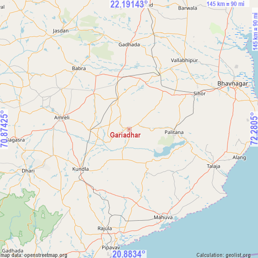
Gariadhar GPS coordinates[2]
21° 32' 20.004" North, 71° 34' 38.532" East
| Map corner | latitude | longitude |
|---|---|---|
| Upper-left | 22.19143°, | 70.87425° |
| Center: | 21.53889°, | 71.57737° |
| Lower-right: | 20.8834°, | 72.2805° |
| Map W x H: | 145.4×145.4 km | = 90.3×90.3mi |
| max Lat: | 34.9274° ⇑58.8% North |
| Gariadhar: | 21.53889° |
| min Lat: | ⇓41.2% South 8.09008° |
| min Long | Gariadhar | max Long |
| 68.82655° | 71.57737° | 96.81° |
| W 2.1%⇐ | ⇒97.9% E |
Elevation
Elevation of Gariadhar is 98 m = 322 ft, and this is 197.6 m = 648 ft below average elevation for this country.
| Max E: |
3681 m = 12077 ft | 68.7% |
| Avg. | 295.6 m = 970 ft | |
| Gariadhar | 98 m = 322 ft | |
Min E: |
1 m = 3 ft | 31.3% |
See also: India elevation on elevation.city.
Geographical zone
Gariadhar is located in North Torrid zone (between Equator and Tropic of Cancer). Distance of this Northern Tropic circle is 211 km =131.1 mi to North.| Distance of | km | miles | from Gariadhar |
|---|---|---|---|
| North Pole | 7612.2 | 4730 | to North |
| Arctic Circle | 5006.3 | 3110.8 | to North |
| Tropic Cancer | 211 | 131.1 | to North |
| Equator | 2394.9 | 1488.1 | to South |


Nearby cities:
15 places around Gariadhar: (largest is in red/bold)
• Amreli
38.4 km =23.9 mi,  280°
280°
• Bābra
44.2 km =27.5 mi,  320°
320°
• Chalāla
44.9 km =27.9 mi,  251°
251°
• Dhola
43.1 km =26.8 mi,  27°
27°
• Dungarpur
33.5 km =20.8 mi,  146°
146°
• Dāmnagar
18.1 km =11.2 mi,  340°
340°
• Gadhada
47.9 km =29.8 mi,  0°
0°
• Kundla
35.6 km =22.1 mi,  232°
232°
• Lāthi
28.3 km =17.6 mi, 316°
• Pālitāna
25.5 km =15.8 mi,  93°
93°
• Savarkundla
36.1 km =22.4 mi, 231°
• Sihor
44.1 km =27.4 mi,  64°
64°
• Talāja
51.7 km =32.1 mi,  113°
113°
• Umrāla
41.1 km =25.5 mi, 34°
• Valabhīpur
49.9 km =31 mi,  38°
38°
Sources, notices
• [Note1] Compared only with cities in India existing in our database
• [Src1] Map data: © OpenStreetMap contributors (CC-BY-SA)
• [Src2] Other city data from geonames.org with taken over terms of usage.
• [Src3] Geographical zone / Annual Mean Temperature by Robert A. Rohde @ Wikipedia
