Chhuīkhadān geodata
Chhuīkhadān (Chhattisgarh) is a populated place; located in India in Asia/Kolkata (GMT+5.5) time zone. With population of 6,485 people, there are 3252 cities with bigger population in this country. Compared to other cities in India, 58.9% of cities are located further ↑North; 72.9% of cities are located further ←West and 71.2% of cities have lower elevation than Chhuīkhadān. Note1


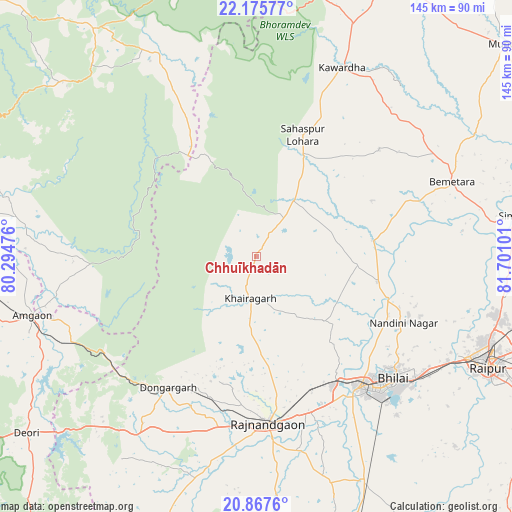
Chhuīkhadān GPS coordinates[2]
21° 31' 23.376" North, 80° 59' 52.368" East
| Map corner | latitude | longitude |
|---|---|---|
| Upper-left | 22.17577°, | 80.29476° |
| Center: | 21.52316°, | 80.99788° |
| Lower-right: | 20.8676°, | 81.70101° |
| Map W x H: | 145.5×145.5 km | = 90.4×90.4mi |
| max Lat: | 34.9274° ⇑58.9% North |
| Chhuīkhadān: | 21.52316° |
| min Lat: | ⇓41.1% South 8.09008° |
| min Long | Chhuīkhadān | max Long |
| 68.82655° | 80.99788° | 96.81° |
| W 72.9%⇐ | ⇒27.1% E |
Elevation
Elevation of Chhuīkhadān is 338 m = 1109 ft, and this is 42.4 m = 139 ft above average elevation for this country.
| Max E: |
3681 m = 12077 ft | 28.8% |
| Chhuīkhadān | 338 m 1109 ft | |
| Avg. | 295.6 m = 970 ft | |
Min E: |
1 m = 3 ft | 71.2% |
See also: India elevation on elevation.city.
Geographical zone
Chhuīkhadān is located in North Torrid zone (between Equator and Tropic of Cancer). Distance of this Northern Tropic circle is 212.8 km =132.2 mi to North.| Distance of | km | miles | from Chhuīkhadān |
|---|---|---|---|
| North Pole | 7613.9 | 4731.1 | to North |
| Arctic Circle | 5008 | 3111.8 | to North |
| Tropic Cancer | 212.8 | 132.2 | to North |
| Equator | 2393.2 | 1487.1 | to South |


Nearby cities:
15 places around Chhuīkhadān: (largest is in red/bold)
• Bemetāra
59.4 km =36.9 mi,  68°
68°
• Bhilai
56.6 km =35.2 mi,  128°
128°
• Bhānpurī
48.4 km =30.1 mi,  188°
188°
• Dongargaon
63.2 km =39.3 mi, 193°
• Dongargarh
44.9 km =27.9 mi,  214°
214°
• Durg
46.8 km =29.1 mi,  141°
141°
• Gandai
19.1 km =11.9 mi,  33°
33°
• Kawardha
59.1 km =36.7 mi,  24°
24°
• Khairāgarh
11.8 km =7.3 mi, 189°
• Kumhāri
60.8 km =37.8 mi,  117°
117°
• Pātan
77.7 km =48.3 mi, 134°
• Raipur
73.3 km =45.5 mi, 116°
• Rāj-Nāndgaon
47.5 km =29.5 mi,  176°
176°
• Simga
73.9 km =45.9 mi,  80°
80°
• Ukwā
74.1 km =46 mi,  312°
312°
Sources, notices
• [Note1] Compared only with cities in India existing in our database
• [Src1] Map data: © OpenStreetMap contributors (CC-BY-SA)
• [Src2] Other city data from geonames.org with taken over terms of usage.
• [Src3] Geographical zone / Annual Mean Temperature by Robert A. Rohde @ Wikipedia
