Gandai geodata
Gandai (Chhattisgarh) is a populated place; located in India in Asia/Kolkata (GMT+5.5) time zone. With population of 12,475 people, there are 2703 cities with bigger population in this country. Compared to other cities in India, 58.2% of cities are located further ↑North; 73.2% of cities are located further ←West and 70% of cities have lower elevation than Gandai. Note1


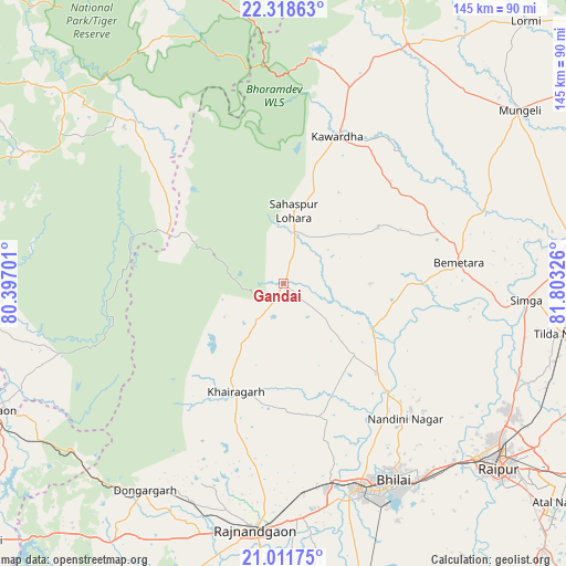
Gandai GPS coordinates[2]
21° 40' 0.012" North, 81° 6' 0.468" East
| Map corner | latitude | longitude |
|---|---|---|
| Upper-left | 22.31863°, | 80.39701° |
| Center: | 21.66667°, | 81.10013° |
| Lower-right: | 21.01175°, | 81.80326° |
| Map W x H: | 145.3×145.3 km | = 90.3×90.3mi |
| max Lat: | 34.9274° ⇑58.2% North |
| Gandai: | 21.66667° |
| min Lat: | ⇓41.8% South 8.09008° |
| min Long | Gandai | max Long |
| 68.82655° | 81.10013° | 96.81° |
| W 73.2%⇐ | ⇒26.8% E |
Elevation
Elevation of Gandai is 327 m = 1073 ft, and this is 31.4 m = 103 ft above average elevation for this country.
| Max E: |
3681 m = 12077 ft | 30% |
| Gandai | 327 m 1073 ft | |
| Avg. | 295.6 m = 970 ft | |
Min E: |
1 m = 3 ft | 70% |
See also: India elevation on elevation.city.
Geographical zone
Gandai is located in North Torrid zone (between Equator and Tropic of Cancer). Distance of this Northern Tropic circle is 196.8 km =122.3 mi to North.| Distance of | km | miles | from Gandai |
|---|---|---|---|
| North Pole | 7598 | 4721.2 | to North |
| Arctic Circle | 4992.1 | 3101.9 | to North |
| Tropic Cancer | 196.8 | 122.3 | to North |
| Equator | 2409.1 | 1496.9 | to South |


Nearby cities:
15 places around Gandai: (largest is in red/bold)
• Bemetāra
45.2 km =28.1 mi,  83°
83°
• Bhilai
61.2 km =38 mi,  146°
146°
• Bhānpurī
66.2 km =41.1 mi,  195°
195°
• Chhuīkhadān
19.1 km =11.9 mi,  213°
213°
• Dongargarh
64 km =39.8 mi, 213°
• Durg
55.9 km =34.7 mi,  160°
160°
• Kawardha
40.4 km =25.1 mi,  19°
19°
• Khairāgarh
30.3 km =18.8 mi, 204°
• Kumhāri
61.9 km =38.5 mi,  135°
135°
• Pandaria
69.8 km =43.4 mi,  27°
27°
• Pāndātarai
62.5 km =38.8 mi, 22°
• Raipur
73.3 km =45.5 mi,  131°
131°
• Rāj-Nāndgaon
63.8 km =39.6 mi,  186°
186°
• Simga
62.5 km =38.8 mi,  93°
93°
• Ukwā
73.7 km =45.8 mi,  297°
297°
Sources, notices
• [Note1] Compared only with cities in India existing in our database
• [Src1] Map data: © OpenStreetMap contributors (CC-BY-SA)
• [Src2] Other city data from geonames.org with taken over terms of usage.
• [Src3] Geographical zone / Annual Mean Temperature by Robert A. Rohde @ Wikipedia
