Rāja Sānsi geodata
Rāja Sānsi (Punjab) is a populated place; located in India in Asia/Kolkata (GMT+5.5) time zone. With population of 12,957 people, there are 2659 cities with bigger population in this country. Compared to other cities in India, 97.4% of cities are located further ↓South; 84.3% of cities are located further →East and 56.7% of cities have lower elevation than Rāja Sānsi. Note1


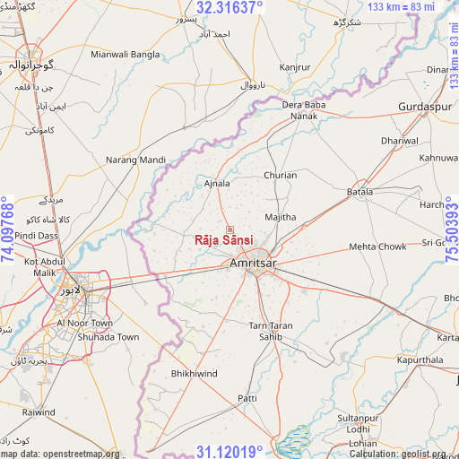
Rāja Sānsi GPS coordinates[2]
31° 43' 12.756" North, 74° 48' 2.88" East
| Map corner | latitude | longitude |
|---|---|---|
| Upper-left | 32.31637°, | 74.09768° |
| Center: | 31.72021°, | 74.8008° |
| Lower-right: | 31.12019°, | 75.50393° |
| Map W x H: | 133×133 km | = 82.6×82.6mi |
| max Lat: | 34.9274° ⇑2.6% North |
| Rāja Sānsi: | 31.72021° |
| min Lat: | ⇓97.4% South 8.09008° |
| min Long | Rāja Sānsi | max Long |
| 68.82655° | 74.8008° | 96.81° |
| W 15.7%⇐ | ⇒84.3% E |
Elevation
Elevation of Rāja Sānsi is 233 m = 764 ft, and this is 62.6 m = 205 ft below average elevation for this country.
| Max E: |
3681 m = 12077 ft | 43.3% |
| Avg. | 295.6 m = 970 ft | |
| Rāja Sānsi | 233 m = 764 ft | |
Min E: |
1 m = 3 ft | 56.7% |
See also: India elevation on elevation.city.
Geographical zone
Rāja Sānsi is located in North temperate zone (between Tropic of Cancer and the Arctic Circle). Distance of this Northern Tropic circle is 921 km =572.3 mi to South.| Distance of | km | miles | from Rāja Sānsi |
|---|---|---|---|
| North Pole | 6480.1 | 4026.5 | to North |
| Arctic Circle | 3874.2 | 2407.3 | to North |
| Tropic Cancer | 921 | 572.3 | to South |
| Equator | 3527 | 2191.6 | to South |


Nearby cities:
15 places around Rāja Sānsi: (largest is in red/bold)
• Ajnāla
14.3 km =8.9 mi,  345°
345°
• Amritsar
13 km =8.1 mi,  147°
147°
• Batāla
39.3 km =24.4 mi,  75°
75°
• Derā Nānak
41.3 km =25.7 mi,  31°
31°
• Dhilwan
56.4 km =35 mi,  113°
113°
• Dhāriwāl
55.9 km =34.7 mi,  62°
62°
• Fatehgarh Chūriān
21.8 km =13.5 mi,  42°
42°
• Jandiāla Gurū
27.8 km =17.3 mi,  129°
129°
• Kalanaur
46.3 km =28.8 mi,  45°
45°
• Kapūrthala
66.7 km =41.4 mi,  124°
124°
• Majītha
15.5 km =9.6 mi,  74°
74°
• Patti
49.1 km =30.5 mi,  173°
173°
• Qādiān
55.6 km =34.5 mi, 78°
• Rām Dās
29.3 km =18.2 mi,  20°
20°
• Tarn Tāran
32.2 km =20 mi,  158°
158°
Sources, notices
• [Note1] Compared only with cities in India existing in our database
• [Src1] Map data: © OpenStreetMap contributors (CC-BY-SA)
• [Src2] Other city data from geonames.org with taken over terms of usage.
• [Src3] Geographical zone / Annual Mean Temperature by Robert A. Rohde @ Wikipedia
