Amritsar geodata
Amritsar (Punjab) is a populated place; located in India in Asia/Kolkata (GMT+5.5) time zone. With population of 1,092,450 people, there are 34 cities with bigger population in this country. Compared to other cities in India, 97.2% of cities are located further ↓South; 83.7% of cities are located further →East and 58.9% of cities have lower elevation than Amritsar. Note1


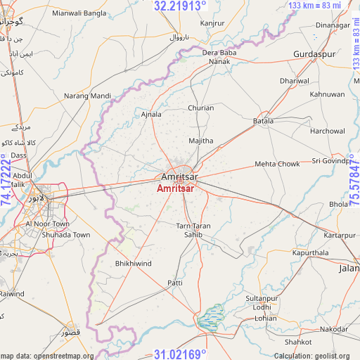
Amritsar GPS coordinates[2]
31° 37' 20.424" North, 74° 52' 31.224" East
| Map corner | latitude | longitude |
|---|---|---|
| Upper-left | 32.21913°, | 74.17222° |
| Center: | 31.62234°, | 74.87534° |
| Lower-right: | 31.02169°, | 75.57847° |
| Map W x H: | 133.1×133.1 km | = 82.7×82.7mi |
| max Lat: | 34.9274° ⇑2.8% North |
| Amritsar: | 31.62234° |
| min Lat: | ⇓97.2% South 8.09008° |
| min Long | Amritsar | max Long |
| 68.82655° | 74.87534° | 96.81° |
| W 16.3%⇐ | ⇒83.7% E |
Elevation
Elevation of Amritsar is 244 m = 801 ft, and this is 51.6 m = 169 ft below average elevation for this country.
| Max E: |
3681 m = 12077 ft | 41.1% |
| Avg. | 295.6 m = 970 ft | |
| Amritsar | 244 m = 801 ft | |
Min E: |
1 m = 3 ft | 58.9% |
See also: Amritsar elevation on elevation.city.
Geographical zone
Amritsar is located in North temperate zone (between Tropic of Cancer and the Arctic Circle). Distance of this Northern Tropic circle is 910.2 km =565.6 mi to South.| Distance of | km | miles | from Amritsar |
|---|---|---|---|
| North Pole | 6491 | 4033.3 | to North |
| Arctic Circle | 3885.1 | 2414.1 | to North |
| Tropic Cancer | 910.2 | 565.6 | to South |
| Equator | 3516.1 | 2184.8 | to South |


Nearby cities:
15 places around Amritsar: (largest is in red/bold)
• Ajnāla
26.9 km =16.7 mi,  336°
336°
• Batāla
37.3 km =23.2 mi,  56°
56°
• Derā Nānak
48.3 km =30 mi,  17°
17°
• Dhilwan
46.2 km =28.7 mi,  105°
105°
• Fatehgarh Chūriān
28 km =17.4 mi, 15°
• Jandiāla Gurū
15.9 km =9.9 mi, 114°
• Kalanaur
50.6 km =31.4 mi,  30°
30°
• Kapūrthala
55 km =34.2 mi,  119°
119°
• Majītha
16.9 km =10.5 mi, 27°
• Patti
38 km =23.6 mi,  182°
182°
• Qādiān
52.4 km =32.6 mi, 64°
• Rāja Sānsi
13 km =8.1 mi,  327°
327°
• Rām Dās
38.5 km =23.9 mi,  4°
4°
• Sultanpur
54.6 km =33.9 mi,  146°
146°
• Tarn Tāran
19.6 km =12.2 mi,  165°
165°
Sources, notices
• [Note1] Compared only with cities in India existing in our database
• [Src1] Map data: © OpenStreetMap contributors (CC-BY-SA)
• [Src2] Other city data from geonames.org with taken over terms of usage.
• [Src3] Geographical zone / Annual Mean Temperature by Robert A. Rohde @ Wikipedia
