Kalanaur geodata
Kalanaur (Punjab) is a populated place; located in India in Asia/Kolkata (GMT+5.5) time zone. With population of 13,671 people, there are 2594 cities with bigger population in this country. Compared to other cities in India, 97.9% of cities are located further ↓South; 81.3% of cities are located further →East and 61.2% of cities have lower elevation than Kalanaur. Note1


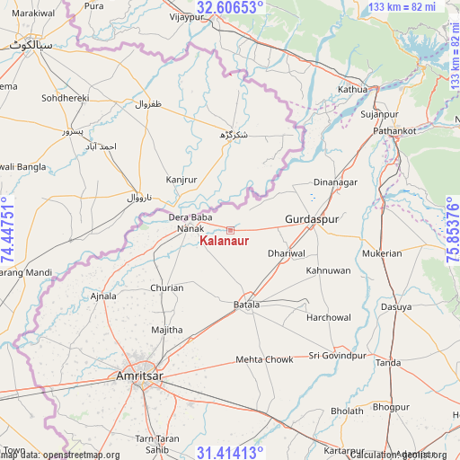
Kalanaur GPS coordinates[2]
32° 0' 44.172" North, 75° 9' 2.268" East
| Map corner | latitude | longitude |
|---|---|---|
| Upper-left | 32.60653°, | 74.44751° |
| Center: | 32.01227°, | 75.15063° |
| Lower-right: | 31.41413°, | 75.85376° |
| Map W x H: | 132.6×132.6 km | = 82.4×82.4mi |
| max Lat: | 34.9274° ⇑2.1% North |
| Kalanaur: | 32.01227° |
| min Lat: | ⇓97.9% South 8.09008° |
| min Long | Kalanaur | max Long |
| 68.82655° | 75.15063° | 96.81° |
| W 18.7%⇐ | ⇒81.3% E |
Elevation
Elevation of Kalanaur is 259 m = 850 ft, and this is 36.6 m = 120 ft below average elevation for this country.
| Max E: |
3681 m = 12077 ft | 38.8% |
| Avg. | 295.6 m = 970 ft | |
| Kalanaur | 259 m = 850 ft | |
Min E: |
1 m = 3 ft | 61.2% |
See also: India elevation on elevation.city.
Geographical zone
Kalanaur is located in North temperate zone (between Tropic of Cancer and the Arctic Circle). Distance of this Northern Tropic circle is 953.5 km =592.5 mi to South.| Distance of | km | miles | from Kalanaur |
|---|---|---|---|
| North Pole | 6447.6 | 4006.4 | to North |
| Arctic Circle | 3841.7 | 2387.1 | to North |
| Tropic Cancer | 953.5 | 592.5 | to South |
| Equator | 3559.4 | 2211.7 | to South |


Nearby cities:
15 places around Kalanaur: (largest is in red/bold)
• Ajnāla
41.1 km =25.5 mi,  243°
243°
• Amritsar
50.6 km =31.4 mi,  210°
210°
• Batāla
23.1 km =14.4 mi,  167°
167°
• Derā Nānak
11.9 km =7.4 mi,  283°
283°
• Dhāriwāl
17.5 km =10.9 mi,  110°
110°
• Dīnānagar
33.4 km =20.8 mi,  65°
65°
• Fatehgarh Chūriān
24.6 km =15.3 mi,  228°
228°
• Hirānagar
50.5 km =31.4 mi,  13°
13°
• Jandiāla Gurū
51.4 km =31.9 mi,  193°
193°
• Majītha
33.7 km =20.9 mi, 212°
• Mukeriān
44.5 km =27.7 mi,  98°
98°
• Parol
45.7 km =28.4 mi,  35°
35°
• Qādiān
30 km =18.6 mi,  134°
134°
• Rāja Sānsi
46.3 km =28.8 mi, 225°
• Rām Dās
23.4 km =14.5 mi,  257°
257°
Sources, notices
• [Note1] Compared only with cities in India existing in our database
• [Src1] Map data: © OpenStreetMap contributors (CC-BY-SA)
• [Src2] Other city data from geonames.org with taken over terms of usage.
• [Src3] Geographical zone / Annual Mean Temperature by Robert A. Rohde @ Wikipedia
