Ajnāla geodata
Ajnāla (Punjab) is a populated place; located in India in Asia/Kolkata (GMT+5.5) time zone. With population of 19,691 people, there are 2063 cities with bigger population in this country. Compared to other cities in India, 97.6% of cities are located further ↓South; 84.7% of cities are located further →East and 56.2% of cities have lower elevation than Ajnāla. Note1


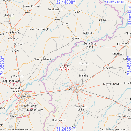
Ajnāla GPS coordinates[2]
31° 50' 41.028" North, 74° 45' 46.62" East
| Map corner | latitude | longitude |
|---|---|---|
| Upper-left | 32.44008°, | 74.05983° |
| Center: | 31.84473°, | 74.76295° |
| Lower-right: | 31.24551°, | 75.46608° |
| Map W x H: | 132.8×132.8 km | = 82.5×82.5mi |
| max Lat: | 34.9274° ⇑2.4% North |
| Ajnāla: | 31.84473° |
| min Lat: | ⇓97.6% South 8.09008° |
| min Long | Ajnāla | max Long |
| 68.82655° | 74.76295° | 96.81° |
| W 15.3%⇐ | ⇒84.7% E |
Elevation
Elevation of Ajnāla is 231 m = 758 ft, and this is 64.6 m = 212 ft below average elevation for this country.
| Max E: |
3681 m = 12077 ft | 43.8% |
| Avg. | 295.6 m = 970 ft | |
| Ajnāla | 231 m = 758 ft | |
Min E: |
1 m = 3 ft | 56.2% |
See also: India elevation on elevation.city.
Geographical zone
Ajnāla is located in North temperate zone (between Tropic of Cancer and the Arctic Circle). Distance of this Northern Tropic circle is 934.9 km =580.9 mi to South.| Distance of | km | miles | from Ajnāla |
|---|---|---|---|
| North Pole | 6466.3 | 4018 | to North |
| Arctic Circle | 3860.4 | 2398.7 | to North |
| Tropic Cancer | 934.9 | 580.9 | to South |
| Equator | 3540.8 | 2200.2 | to South |


Nearby cities:
15 places around Ajnāla: (largest is in red/bold)
• Amritsar
26.9 km =16.7 mi,  156°
156°
• Batāla
41.8 km =26 mi,  95°
95°
• Derā Nānak
32.9 km =20.4 mi,  49°
49°
• Dhilwan
66.3 km =41.2 mi,  123°
123°
• Dhāriwāl
54.4 km =33.8 mi,  76°
76°
• Dīnānagar
74.4 km =46.2 mi,  64°
64°
• Fatehgarh Chūriān
18.4 km =11.4 mi, 83°
• Jandiāla Gurū
40.2 km =25 mi,  141°
141°
• Kalanaur
41.1 km =25.5 mi, 63°
• Majītha
20.9 km =13 mi, 117°
• Patti
63.3 km =39.3 mi,  171°
171°
• Qādiān
58 km =36 mi,  92°
92°
• Rāja Sānsi
14.3 km =8.9 mi, 165°
• Rām Dās
19.4 km =12.1 mi, 45°
• Tarn Tāran
46.4 km =28.8 mi, 160°
Sources, notices
• [Note1] Compared only with cities in India existing in our database
• [Src1] Map data: © OpenStreetMap contributors (CC-BY-SA)
• [Src2] Other city data from geonames.org with taken over terms of usage.
• [Src3] Geographical zone / Annual Mean Temperature by Robert A. Rohde @ Wikipedia
