Kollam geodata
Kollam (Kerala) is a seat of a second-order administrative division; located in India in Asia/Kolkata (GMT+5.5) time zone. With population of 394,163 people, there are 116 cities with bigger population in this country. Compared to other cities in India, 98.9% of cities are located further ↑North; 67.4% of cities are located further →East and 93.5% of cities have higher elevation than Kollam. Note1


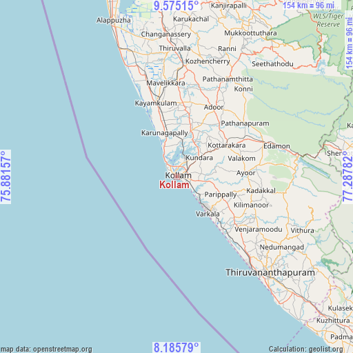
Kollam GPS coordinates[2]
8° 52' 52.068" North, 76° 35' 4.884" East
| Map corner | latitude | longitude |
|---|---|---|
| Upper-left | 9.57515°, | 75.88157° |
| Center: | 8.88113°, | 76.58469° |
| Lower-right: | 8.18579°, | 77.28782° |
| Map W x H: | 154.5×154.5 km | = 96×96mi |
| max Lat: | 34.9274° ⇑98.9% North |
| Kollam: | 8.88113° |
| min Lat: | ⇓1.1% South 8.09008° |
| min Long | Kollam | max Long |
| 68.82655° | 76.58469° | 96.81° |
| W 32.6%⇐ | ⇒67.4% E |
Elevation
Elevation of Kollam is 13 m = 43 ft, and this is 282.6 m = 927 ft below average elevation for this country.
| Max E: |
3681 m = 12077 ft | 93.5% |
| Avg. | 295.6 m = 970 ft | |
| Kollam | 13 m = 43 ft | |
Min E: |
1 m = 3 ft | 6.5% |
See also: Kollam elevation on elevation.city.
Geographical zone
Kollam is located in North Torrid zone (between Equator and Tropic of Cancer). Distance of Equator is 987.5 km =613.6 mi to South.| Distance of | km | miles | from Kollam |
|---|---|---|---|
| North Pole | 9019.6 | 5604.5 | to North |
| Arctic Circle | 6413.7 | 3985.3 | to North |
| Tropic Cancer | 1618.4 | 1005.6 | to North |
| Equator | 987.5 | 613.6 | to South |


Nearby cities:
15 places around Kollam: (largest is in red/bold)
• Adūr
34.6 km =21.5 mi,  27°
27°
• Attingal
32.6 km =20.3 mi,  129°
129°
• Chengannūr
48.4 km =30.1 mi,  3°
3°
• Kadakkavoor
30.1 km =18.7 mi,  138°
138°
• Kattanam
32.9 km =20.4 mi,  355°
355°
• Kāyankulam
34.7 km =21.6 mi,  344°
344°
• Māvelikara
42.2 km =26.2 mi, 355°
• Nedumangād
55.3 km =34.4 mi,  124°
124°
• Paravūr Tekkumbhāgam
13.3 km =8.3 mi, 136°
• Pathanāmthitta
48.1 km =29.9 mi, 26°
• Ponmana
15.8 km =9.8 mi,  333°
333°
• Punalūr
40.2 km =25 mi,  67°
67°
• Tiruvalla
55.7 km =34.6 mi, 358°
• Varkala
21.9 km =13.6 mi, 138°
• Vettūr
23.9 km =14.9 mi, 139°
Sources, notices
• [Note1] Compared only with cities in India existing in our database
• [Src1] Map data: © OpenStreetMap contributors (CC-BY-SA)
• [Src2] Other city data from geonames.org with taken over terms of usage.
• [Src3] Geographical zone / Annual Mean Temperature by Robert A. Rohde @ Wikipedia
