Attingal geodata
Attingal (Kerala) is a populated place; located in India in Asia/Kolkata (GMT+5.5) time zone. With population of 36,595 people, there are 1199 cities with bigger population in this country. Compared to other cities in India, 99.3% of cities are located further ↑North; 65% of cities are located further →East and 81.4% of cities have higher elevation than Attingal. Note1


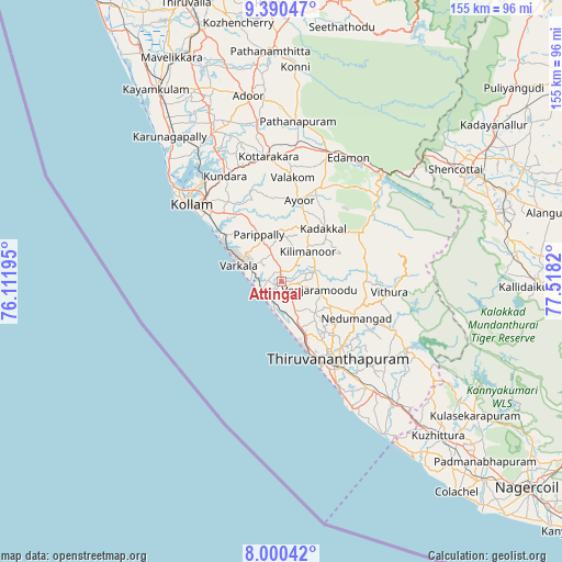
Attingal GPS coordinates[2]
8° 41' 45.924" North, 76° 48' 54.252" East
| Map corner | latitude | longitude |
|---|---|---|
| Upper-left | 9.39047°, | 76.11195° |
| Center: | 8.69609°, | 76.81507° |
| Lower-right: | 8.00042°, | 77.5182° |
| Map W x H: | 154.6×154.6 km | = 96.1×96.1mi |
| max Lat: | 34.9274° ⇑99.3% North |
| Attingal: | 8.69609° |
| min Lat: | ⇓0.7% South 8.09008° |
| min Long | Attingal | max Long |
| 68.82655° | 76.81507° | 96.81° |
| W 35%⇐ | ⇒65% E |
Elevation
Elevation of Attingal is 43 m = 141 ft, and this is 252.6 m = 829 ft below average elevation for this country.
| Max E: |
3681 m = 12077 ft | 81.4% |
| Avg. | 295.6 m = 970 ft | |
| Attingal | 43 m = 141 ft | |
Min E: |
1 m = 3 ft | 18.6% |
See also: India elevation on elevation.city.
Geographical zone
Attingal is located in North Torrid zone (between Equator and Tropic of Cancer). Distance of Equator is 966.9 km =600.8 mi to South.| Distance of | km | miles | from Attingal |
|---|---|---|---|
| North Pole | 9040.1 | 5617.3 | to North |
| Arctic Circle | 6434.3 | 3998.1 | to North |
| Tropic Cancer | 1639 | 1018.4 | to North |
| Equator | 966.9 | 600.8 | to South |


Nearby cities:
15 places around Attingal: (largest is in red/bold)
• Adūr
51.9 km =32.2 mi,  349°
349°
• Kadakkavoor
5.6 km =3.5 mi,  250°
250°
• Kattanam
60.1 km =37.3 mi,  332°
332°
• Kollam
32.6 km =20.3 mi,  309°
309°
• Kovalam
41.7 km =25.9 mi,  151°
151°
• Kuttālam
56.3 km =35 mi,  62°
62°
• Kuzhithurai
59 km =36.7 mi,  135°
135°
• Nedumangād
23 km =14.3 mi,  116°
116°
• Neyyāttinkara
44.5 km =27.7 mi, 138°
• Paravūr Tekkumbhāgam
19.5 km =12.1 mi,  304°
304°
• Ponmana
47.5 km =29.5 mi,  316°
316°
• Punalūr
37.9 km =23.5 mi,  18°
18°
• Thiruvananthapuram
27.7 km =17.2 mi, 147°
• Varkala
11.6 km =7.2 mi,  290°
290°
• Vettūr
10.1 km =6.3 mi,  283°
283°
Sources, notices
• [Note1] Compared only with cities in India existing in our database
• [Src1] Map data: © OpenStreetMap contributors (CC-BY-SA)
• [Src2] Other city data from geonames.org with taken over terms of usage.
• [Src3] Geographical zone / Annual Mean Temperature by Robert A. Rohde @ Wikipedia
