Varkala geodata
Varkala (Kerala) is a populated place; located in India in Asia/Kolkata (GMT+5.5) time zone. With population of 43,276 people, there are 1020 cities with bigger population in this country. Compared to other cities in India, 99.1% of cities are located further ↑North; 66.2% of cities are located further →East and 79.9% of cities have higher elevation than Varkala. Note1


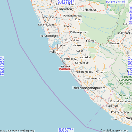
Varkala GPS coordinates[2]
8° 43' 59.88" North, 76° 43' 0.12" East
| Map corner | latitude | longitude |
|---|---|---|
| Upper-left | 9.42761°, | 76.01358° |
| Center: | 8.7333°, | 76.7167° |
| Lower-right: | 8.0377°, | 77.41983° |
| Map W x H: | 154.5×154.5 km | = 96×96mi |
| max Lat: | 34.9274° ⇑99.1% North |
| Varkala: | 8.7333° |
| min Lat: | ⇓0.9% South 8.09008° |
| min Long | Varkala | max Long |
| 68.82655° | 76.7167° | 96.81° |
| W 33.8%⇐ | ⇒66.2% E |
Elevation
Elevation of Varkala is 48 m = 157 ft, and this is 247.6 m = 812 ft below average elevation for this country.
| Max E: |
3681 m = 12077 ft | 79.9% |
| Avg. | 295.6 m = 970 ft | |
| Varkala | 48 m = 157 ft | |
Min E: |
1 m = 3 ft | 20.1% |
See also: Varkala elevation on elevation.city.
Geographical zone
Varkala is located in North Torrid zone (between Equator and Tropic of Cancer). Distance of Equator is 971.1 km =603.4 mi to South.| Distance of | km | miles | from Varkala |
|---|---|---|---|
| North Pole | 9036 | 5614.7 | to North |
| Arctic Circle | 6430.1 | 3995.5 | to North |
| Tropic Cancer | 1634.9 | 1015.9 | to North |
| Equator | 971.1 | 603.4 | to South |


Nearby cities:
15 places around Varkala: (largest is in red/bold)
• Adūr
47 km =29.2 mi,  2°
2°
• Attingal
11.6 km =7.2 mi,  110°
110°
• Kadakkavoor
8.2 km =5.1 mi,  137°
137°
• Kattanam
52 km =32.3 mi,  341°
341°
• Kollam
21.9 km =13.6 mi,  318°
318°
• Kovalam
51.1 km =31.8 mi, 142°
• Kāyankulam
55.2 km =34.3 mi,  334°
334°
• Nedumangād
34.5 km =21.4 mi, 114°
• Neyyāttinkara
55.1 km =34.2 mi,  132°
132°
• Paravūr Tekkumbhāgam
8.7 km =5.4 mi, 321°
• Pathanāmthitta
59.8 km =37.2 mi,  7°
7°
• Ponmana
37.4 km =23.2 mi, 324°
• Punalūr
39 km =24.2 mi,  35°
35°
• Thiruvananthapuram
37.6 km =23.4 mi, 137°
• Vettūr
2 km =1.2 mi,  150°
150°
Sources, notices
• [Note1] Compared only with cities in India existing in our database
• [Src1] Map data: © OpenStreetMap contributors (CC-BY-SA)
• [Src2] Other city data from geonames.org with taken over terms of usage.
• [Src3] Geographical zone / Annual Mean Temperature by Robert A. Rohde @ Wikipedia
