Nedumangād geodata
Nedumangād (Kerala) is a populated place; located in India in Asia/Kolkata (GMT+5.5) time zone. With population of 58,278 people, there are 756 cities with bigger population in this country. Compared to other cities in India, 99.4% of cities are located further ↑North; 63.1% of cities are located further →East and 77.5% of cities have higher elevation than Nedumangād. Note1


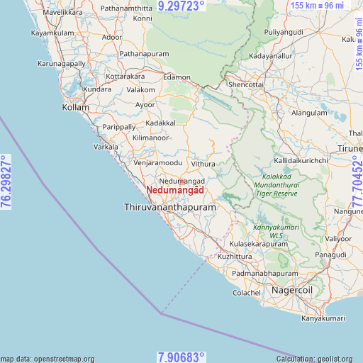
Nedumangād GPS coordinates[2]
8° 36' 9.612" North, 77° 0' 5.004" East
| Map corner | latitude | longitude |
|---|---|---|
| Upper-left | 9.29723°, | 76.29827° |
| Center: | 8.60267°, | 77.00139° |
| Lower-right: | 7.90683°, | 77.70452° |
| Map W x H: | 154.6×154.6 km | = 96.1×96.1mi |
| max Lat: | 34.9274° ⇑99.4% North |
| Nedumangād: | 8.60267° |
| min Lat: | ⇓0.6% South 8.09008° |
| min Long | Nedumangād | max Long |
| 68.82655° | 77.00139° | 96.81° |
| W 36.9%⇐ | ⇒63.1% E |
Elevation
Elevation of Nedumangād is 57 m = 187 ft, and this is 238.6 m = 783 ft below average elevation for this country.
| Max E: |
3681 m = 12077 ft | 77.5% |
| Avg. | 295.6 m = 970 ft | |
| Nedumangād | 57 m = 187 ft | |
Min E: |
1 m = 3 ft | 22.5% |
See also: Nedumangād elevation on elevation.city.
Geographical zone
Nedumangād is located in North Torrid zone (between Equator and Tropic of Cancer). Distance of Equator is 956.5 km =594.3 mi to South.| Distance of | km | miles | from Nedumangād |
|---|---|---|---|
| North Pole | 9050.5 | 5623.7 | to North |
| Arctic Circle | 6444.6 | 4004.5 | to North |
| Tropic Cancer | 1649.4 | 1024.9 | to North |
| Equator | 956.5 | 594.3 | to South |


Nearby cities:
15 places around Nedumangād: (largest is in red/bold)
• Ambasamudram
51 km =31.7 mi,  76°
76°
• Attingal
23 km =14.3 mi,  296°
296°
• Kadakkavoor
27.1 km =16.8 mi,  288°
288°
• Kallidaikurichi
51.9 km =32.2 mi, 79°
• Kovalam
26.2 km =16.3 mi,  181°
181°
• Kuttālam
46.9 km =29.1 mi,  38°
38°
• Kuzhithurai
38 km =23.6 mi,  146°
146°
• Neyyāttinkara
24.5 km =15.2 mi,  157°
157°
• Padmanābhapuram
53.5 km =33.2 mi,  138°
138°
• Paravūr Tekkumbhāgam
42.4 km =26.3 mi, 300°
• Punalūr
47.2 km =29.3 mi,  349°
349°
• Thenkasi
52.6 km =32.7 mi, 40°
• Thiruvananthapuram
14.2 km =8.8 mi,  203°
203°
• Varkala
34.5 km =21.4 mi, 294°
• Vettūr
32.9 km =20.4 mi, 292°
Sources, notices
• [Note1] Compared only with cities in India existing in our database
• [Src1] Map data: © OpenStreetMap contributors (CC-BY-SA)
• [Src2] Other city data from geonames.org with taken over terms of usage.
• [Src3] Geographical zone / Annual Mean Temperature by Robert A. Rohde @ Wikipedia
