Paravūr Tekkumbhāgam geodata
Paravūr Tekkumbhāgam (Kerala) is a populated place; located in India in Asia/Kolkata (GMT+5.5) time zone. With population of 38,946 people, there are 1133 cities with bigger population in this country. Compared to other cities in India, 99% of cities are located further ↑North; 66.6% of cities are located further →East and 87.6% of cities have higher elevation than Paravūr Tekkumbhāgam. Note1


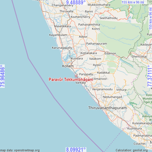
Paravūr Tekkumbhāgam GPS coordinates[2]
8° 47' 40.92" North, 76° 40' 4.728" East
| Map corner | latitude | longitude |
|---|---|---|
| Upper-left | 9.48889°, | 75.96486° |
| Center: | 8.7947°, | 76.66798° |
| Lower-right: | 8.09921°, | 77.37111° |
| Map W x H: | 154.5×154.5 km | = 96×96mi |
| max Lat: | 34.9274° ⇑99% North |
| Paravūr Tekkumbhāgam: | 8.7947° |
| min Lat: | ⇓1% South 8.09008° |
| min Long | Paravūr Tekkum | max Long |
| 68.82655° | 76.66798° | 96.81° |
| W 33.4%⇐ | ⇒66.6% E |
Elevation
Elevation of Paravūr Tekkumbhāgam is 23 m = 75 ft, and this is 272.6 m = 894 ft below average elevation for this country.
| Max E: |
3681 m = 12077 ft | 87.6% |
| Avg. | 295.6 m = 970 ft | |
| Paravūr Tekkumbhāgam | 23 m = 75 ft | |
Min E: |
1 m = 3 ft | 12.4% |
See also: India elevation on elevation.city.
Geographical zone
Paravūr Tekkumbhāgam is located in North Torrid zone (between Equator and Tropic of Cancer). Distance of Equator is 977.9 km =607.6 mi to South.| Distance of | km | miles | from Paravūr Tekkumbhāgam |
|---|---|---|---|
| North Pole | 9029.2 | 5610.5 | to North |
| Arctic Circle | 6423.3 | 3991.3 | to North |
| Tropic Cancer | 1628 | 1011.6 | to North |
| Equator | 977.9 | 607.6 | to South |


Nearby cities:
15 places around Paravūr Tekkumbhāgam: (largest is in red/bold)
• Adūr
40.8 km =25.4 mi,  9°
9°
• Attingal
19.5 km =12.1 mi,  124°
124°
• Chengannūr
58.2 km =36.2 mi,  354°
354°
• Kadakkavoor
16.8 km =10.4 mi,  139°
139°
• Kattanam
43.9 km =27.3 mi,  344°
344°
• Kollam
13.3 km =8.3 mi,  316°
316°
• Kāyankulam
46.8 km =29.1 mi, 336°
• Māvelikara
53.1 km =33 mi, 346°
• Nedumangād
42.4 km =26.3 mi, 120°
• Pathanāmthitta
54 km =33.6 mi, 13°
• Ponmana
28.7 km =17.8 mi,  325°
325°
• Punalūr
37.5 km =23.3 mi,  48°
48°
• Thiruvananthapuram
46.2 km =28.7 mi, 138°
• Varkala
8.7 km =5.4 mi, 141°
• Vettūr
10.7 km =6.6 mi, 143°
Sources, notices
• [Note1] Compared only with cities in India existing in our database
• [Src1] Map data: © OpenStreetMap contributors (CC-BY-SA)
• [Src2] Other city data from geonames.org with taken over terms of usage.
• [Src3] Geographical zone / Annual Mean Temperature by Robert A. Rohde @ Wikipedia
