Pudūr geodata
Pudūr (Tamil Nadu) is a populated place; located in India in Asia/Kolkata (GMT+5.5) time zone. With population of 11,432 people, there are 2785 cities with bigger population in this country. Compared to other cities in India, 86.4% of cities are located further ↑North; 60.4% of cities are located further ←West and 56.9% of cities have lower elevation than Pudūr. Note1


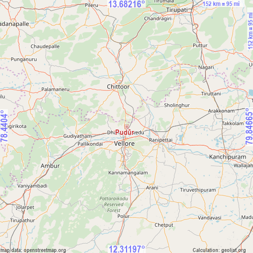
Pudūr GPS coordinates[2]
12° 59' 52.836" North, 79° 8' 36.672" East
| Map corner | latitude | longitude |
|---|---|---|
| Upper-left | 13.68216°, | 78.4404° |
| Center: | 12.99801°, | 79.14352° |
| Lower-right: | 12.31197°, | 79.84665° |
| Map W x H: | 152.4×152.4 km | = 94.7×94.7mi |
| max Lat: | 34.9274° ⇑86.4% North |
| Pudūr: | 12.99801° |
| min Lat: | ⇓13.6% South 8.09008° |
| min Long | Pudūr | max Long |
| 68.82655° | 79.14352° | 96.81° |
| W 60.4%⇐ | ⇒39.6% E |
Elevation
Elevation of Pudūr is 234 m = 768 ft, and this is 61.6 m = 202 ft below average elevation for this country.
| Max E: |
3681 m = 12077 ft | 43.1% |
| Avg. | 295.6 m = 970 ft | |
| Pudūr | 234 m = 768 ft | |
Min E: |
1 m = 3 ft | 56.9% |
See also: India elevation on elevation.city.
Geographical zone
Pudūr is located in North Torrid zone (between Equator and Tropic of Cancer). Distance of this Northern Tropic circle is 1160.7 km =721.2 mi to North.| Distance of | km | miles | from Pudūr |
|---|---|---|---|
| North Pole | 8561.8 | 5320.1 | to North |
| Arctic Circle | 5955.9 | 3700.8 | to North |
| Tropic Cancer | 1160.7 | 721.2 | to North |
| Equator | 1445.2 | 898 | to South |


Nearby cities:
15 places around Pudūr: (largest is in red/bold)
• Arcot
21.6 km =13.4 mi,  118°
118°
• Arni
39.8 km =24.7 mi,  157°
157°
• Chittoor
24.2 km =15 mi,  347°
347°
• Gudiyatham
29.8 km =18.5 mi,  258°
258°
• Kalavai
39.2 km =24.4 mi,  130°
130°
• Kātpādi
3.2 km =2 mi,  176°
176°
• Odugattūr
38.1 km =23.7 mi,  227°
227°
• Pallikondai
24.1 km =15 mi,  244°
244°
• Pallipattu
50 km =31.1 mi,  40°
40°
• Palmaner
48.4 km =30.1 mi,  297°
297°
• Peranāmpattu
46.6 km =29 mi, 261°
• Rāmāpuram
12.3 km =7.6 mi,  21°
21°
• Sholinghur
32.8 km =20.4 mi,  65°
65°
• Vellore
8.9 km =5.5 mi,  187°
187°
• Walajapet
25.5 km =15.8 mi,  108°
108°
Sources, notices
• [Note1] Compared only with cities in India existing in our database
• [Src1] Map data: © OpenStreetMap contributors (CC-BY-SA)
• [Src2] Other city data from geonames.org with taken over terms of usage.
• [Src3] Geographical zone / Annual Mean Temperature by Robert A. Rohde @ Wikipedia
