Arcot geodata
Arcot (Tamil Nadu) is a populated place; located in India in Asia/Kolkata (GMT+5.5) time zone. With population of 51,943 people, there are 858 cities with bigger population in this country. Compared to other cities in India, 87% of cities are located further ↑North; 62% of cities are located further ←West and 55.3% of cities have higher elevation than Arcot. Note1


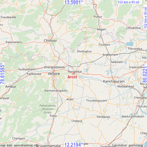
Arcot GPS coordinates[2]
12° 54' 20.484" North, 79° 19' 8.292" East
| Map corner | latitude | longitude |
|---|---|---|
| Upper-left | 13.5901°, | 78.61585° |
| Center: | 12.90569°, | 79.31897° |
| Lower-right: | 12.2194°, | 80.0221° |
| Map W x H: | 152.4×152.4 km | = 94.7×94.7mi |
| max Lat: | 34.9274° ⇑87% North |
| Arcot: | 12.90569° |
| min Lat: | ⇓13% South 8.09008° |
| min Long | Arcot | max Long |
| 68.82655° | 79.31897° | 96.81° |
| W 62%⇐ | ⇒38% E |
Elevation
Elevation of Arcot is 173 m = 568 ft, and this is 122.6 m = 402 ft below average elevation for this country.
| Max E: |
3681 m = 12077 ft | 55.3% |
| Avg. | 295.6 m = 970 ft | |
| Arcot | 173 m = 568 ft | |
Min E: |
1 m = 3 ft | 44.7% |
See also: Arcot elevation on elevation.city.
Geographical zone
Arcot is located in North Torrid zone (between Equator and Tropic of Cancer). Distance of this Northern Tropic circle is 1170.9 km =727.6 mi to North.| Distance of | km | miles | from Arcot |
|---|---|---|---|
| North Pole | 8572.1 | 5326.5 | to North |
| Arctic Circle | 5966.2 | 3707.2 | to North |
| Tropic Cancer | 1170.9 | 727.6 | to North |
| Equator | 1435 | 891.7 | to South |


Nearby cities:
15 places around Arcot: (largest is in red/bold)
• Arakkonam
43 km =26.7 mi,  62°
62°
• Arni
26.7 km =16.6 mi,  187°
187°
• Cheyyar
36.5 km =22.7 mi,  138°
138°
• Chittoor
41.6 km =25.8 mi,  324°
324°
• Dūsi
41.6 km =25.8 mi,  110°
110°
• Kalavai
18.6 km =11.6 mi, 143°
• Kanchipuram
42 km =26.1 mi,  100°
100°
• Kātpādi
20.1 km =12.5 mi,  290°
290°
• Pallikondai
40.8 km =25.4 mi,  269°
269°
• Peranamallūr
39.3 km =24.4 mi,  161°
161°
• Pudūr
21.6 km =13.4 mi,  298°
298°
• Rāmāpuram
26.2 km =16.3 mi,  326°
326°
• Sholinghur
26 km =16.2 mi,  24°
24°
• Vellore
20.3 km =12.6 mi, 274°
• Walajapet
5.6 km =3.5 mi,  67°
67°
Sources, notices
• [Note1] Compared only with cities in India existing in our database
• [Src1] Map data: © OpenStreetMap contributors (CC-BY-SA)
• [Src2] Other city data from geonames.org with taken over terms of usage.
• [Src3] Geographical zone / Annual Mean Temperature by Robert A. Rohde @ Wikipedia
