Vellore geodata
Vellore (Tamil Nadu) is a populated place; located in India in Asia/Kolkata (GMT+5.5) time zone. With population of 177,081 people, there are 240 cities with bigger population in this country. Compared to other cities in India, 86.9% of cities are located further ↑North; 60.3% of cities are located further ←West and 53% of cities have lower elevation than Vellore. Note1


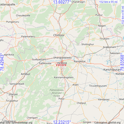
Vellore GPS coordinates[2]
12° 55' 6.24" North, 79° 7' 57.18" East
| Map corner | latitude | longitude |
|---|---|---|
| Upper-left | 13.60277°, | 78.42943° |
| Center: | 12.9184°, | 79.13255° |
| Lower-right: | 12.23215°, | 79.83568° |
| Map W x H: | 152.4×152.4 km | = 94.7×94.7mi |
| max Lat: | 34.9274° ⇑86.9% North |
| Vellore: | 12.9184° |
| min Lat: | ⇓13.1% South 8.09008° |
| min Long | Vellore | max Long |
| 68.82655° | 79.13255° | 96.81° |
| W 60.3%⇐ | ⇒39.7% E |
Elevation
Elevation of Vellore is 218 m = 715 ft, and this is 77.6 m = 255 ft below average elevation for this country.
| Max E: |
3681 m = 12077 ft | 47% |
| Avg. | 295.6 m = 970 ft | |
| Vellore | 218 m = 715 ft | |
Min E: |
1 m = 3 ft | 53% |
See also: Vellore elevation on elevation.city.
Geographical zone
Vellore is located in North Torrid zone (between Equator and Tropic of Cancer). Distance of this Northern Tropic circle is 1169.5 km =726.7 mi to North.| Distance of | km | miles | from Vellore |
|---|---|---|---|
| North Pole | 8570.7 | 5325.6 | to North |
| Arctic Circle | 5964.8 | 3706.4 | to North |
| Tropic Cancer | 1169.5 | 726.7 | to North |
| Equator | 1436.4 | 892.5 | to South |


Nearby cities:
15 places around Vellore: (largest is in red/bold)
• Ambur
47.3 km =29.4 mi,  252°
252°
• Arcot
20.3 km =12.6 mi,  94°
94°
• Arni
32.4 km =20.1 mi,  149°
149°
• Chittoor
32.7 km =20.3 mi,  352°
352°
• Gudiyatham
28.2 km =17.5 mi,  276°
276°
• Kalavai
35.2 km =21.9 mi,  117°
117°
• Kātpādi
5.9 km =3.7 mi,  13°
13°
• Odugattūr
31.8 km =19.8 mi,  238°
238°
• Pallikondai
20.6 km =12.8 mi,  265°
265°
• Peranāmpattu
44.9 km =27.9 mi, 272°
• Polūr
45.2 km =28.1 mi,  181°
181°
• Pudūr
8.9 km =5.5 mi, 7°
• Rāmāpuram
21 km =13 mi,  15°
15°
• Sholinghur
38.3 km =23.8 mi,  54°
54°
• Walajapet
25.3 km =15.7 mi, 88°
Sources, notices
• [Note1] Compared only with cities in India existing in our database
• [Src1] Map data: © OpenStreetMap contributors (CC-BY-SA)
• [Src2] Other city data from geonames.org with taken over terms of usage.
• [Src3] Geographical zone / Annual Mean Temperature by Robert A. Rohde @ Wikipedia
