Peranāmpattu geodata
Peranāmpattu (Tamil Nadu) is a populated place; located in India in Asia/Kolkata (GMT+5.5) time zone. With population of 43,124 people, there are 1024 cities with bigger population in this country. Compared to other cities in India, 86.8% of cities are located further ↑North; 56% of cities are located further ←West and 73.6% of cities have lower elevation than Peranāmpattu. Note1


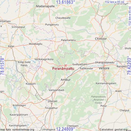
Peranāmpattu GPS coordinates[2]
12° 56' 3.48" North, 78° 43' 8.04" East
| Map corner | latitude | longitude |
|---|---|---|
| Upper-left | 13.61863°, | 78.01578° |
| Center: | 12.9343°, | 78.7189° |
| Lower-right: | 12.24809°, | 79.42203° |
| Map W x H: | 152.4×152.4 km | = 94.7×94.7mi |
| max Lat: | 34.9274° ⇑86.8% North |
| Peranāmpattu: | 12.9343° |
| min Lat: | ⇓13.2% South 8.09008° |
| min Long | Peranāmpattu | max Long |
| 68.82655° | 78.7189° | 96.81° |
| W 56%⇐ | ⇒44% E |
Elevation
Elevation of Peranāmpattu is 369 m = 1211 ft, and this is 73.4 m = 241 ft above average elevation for this country.
| Max E: |
3681 m = 12077 ft | 26.4% |
| Peranāmpattu | 369 m 1211 ft | |
| Avg. | 295.6 m = 970 ft | |
Min E: |
1 m = 3 ft | 73.6% |
See also: Peranāmpattu elevation on elevation.city.
Geographical zone
Peranāmpattu is located in North Torrid zone (between Equator and Tropic of Cancer). Distance of this Northern Tropic circle is 1167.8 km =725.6 mi to North.| Distance of | km | miles | from Peranāmpattu |
|---|---|---|---|
| North Pole | 8568.9 | 5324.5 | to North |
| Arctic Circle | 5963 | 3705.2 | to North |
| Tropic Cancer | 1167.8 | 725.6 | to North |
| Equator | 1438.2 | 893.7 | to South |


Nearby cities:
15 places around Peranāmpattu: (largest is in red/bold)
• Alangāyam
34.9 km =21.7 mi,  174°
174°
• Ambur
15.9 km =9.9 mi,  180°
180°
• Gudiyatham
16.8 km =10.4 mi,  85°
85°
• Jalārpet
43.5 km =27 mi,  201°
201°
• Kuppam
45.8 km =28.5 mi,  243°
243°
• Kātpādi
46.4 km =28.8 mi, 85°
• Mulbāgal
43.5 km =27 mi,  305°
305°
• Odugattūr
25.7 km =16 mi,  136°
136°
• Pallikondai
24.5 km =15.2 mi,  97°
97°
• Palmaner
29.7 km =18.5 mi,  5°
5°
• Pudūr
46.6 km =29 mi,  81°
81°
• Punganūru
50.6 km =31.4 mi,  341°
341°
• Robertsonpet
48.1 km =29.9 mi,  272°
272°
• Vaniyambadi
30.1 km =18.7 mi, 200°
• Vellore
44.9 km =27.9 mi, 92°
Sources, notices
• [Note1] Compared only with cities in India existing in our database
• [Src1] Map data: © OpenStreetMap contributors (CC-BY-SA)
• [Src2] Other city data from geonames.org with taken over terms of usage.
• [Src3] Geographical zone / Annual Mean Temperature by Robert A. Rohde @ Wikipedia
