Odugattūr geodata
Odugattūr (Tamil Nadu) is a populated place; located in India in Asia/Kolkata (GMT+5.5) time zone. With population of 8,282 people, there are 3101 cities with bigger population in this country. Compared to other cities in India, 87.5% of cities are located further ↑North; 57.9% of cities are located further ←West and 70.6% of cities have lower elevation than Odugattūr. Note1


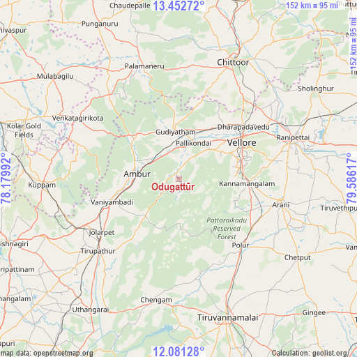
Odugattūr GPS coordinates[2]
12° 46' 4.548" North, 78° 52' 58.944" East
| Map corner | latitude | longitude |
|---|---|---|
| Upper-left | 13.45272°, | 78.17992° |
| Center: | 12.76793°, | 78.88304° |
| Lower-right: | 12.08128°, | 79.58617° |
| Map W x H: | 152.5×152.5 km | = 94.8×94.8mi |
| max Lat: | 34.9274° ⇑87.5% North |
| Odugattūr: | 12.76793° |
| min Lat: | ⇓12.5% South 8.09008° |
| min Long | Odugattūr | max Long |
| 68.82655° | 78.88304° | 96.81° |
| W 57.9%⇐ | ⇒42.1% E |
Elevation
Elevation of Odugattūr is 333 m = 1093 ft, and this is 37.4 m = 123 ft above average elevation for this country.
| Max E: |
3681 m = 12077 ft | 29.4% |
| Odugattūr | 333 m 1093 ft | |
| Avg. | 295.6 m = 970 ft | |
Min E: |
1 m = 3 ft | 70.6% |
See also: India elevation on elevation.city.
Geographical zone
Odugattūr is located in North Torrid zone (between Equator and Tropic of Cancer). Distance of this Northern Tropic circle is 1186.3 km =737.1 mi to North.| Distance of | km | miles | from Odugattūr |
|---|---|---|---|
| North Pole | 8587.4 | 5336 | to North |
| Arctic Circle | 5981.5 | 3716.7 | to North |
| Tropic Cancer | 1186.3 | 737.1 | to North |
| Equator | 1419.7 | 882.2 | to South |


Nearby cities:
15 places around Odugattūr: (largest is in red/bold)
• Alangāyam
21.5 km =13.4 mi,  221°
221°
• Ambur
18.3 km =11.4 mi,  278°
278°
• Arcot
49.7 km =30.9 mi,  72°
72°
• Arni
45 km =28 mi,  104°
104°
• Gudiyatham
19.8 km =12.3 mi,  357°
357°
• Jalārpet
40.2 km =25 mi,  236°
236°
• Kātpādi
36.2 km =22.5 mi,  51°
51°
• Pallikondai
16.6 km =10.3 mi,  22°
22°
• Palmaner
50.2 km =31.2 mi,  342°
342°
• Peranāmpattu
25.7 km =16 mi,  316°
316°
• Polūr
38.6 km =24 mi,  137°
137°
• Pudūr
38.1 km =23.7 mi, 47°
• Rāmāpuram
49.3 km =30.6 mi,  41°
41°
• Vaniyambadi
30.1 km =18.7 mi,  251°
251°
• Vellore
31.8 km =19.8 mi,  58°
58°
Sources, notices
• [Note1] Compared only with cities in India existing in our database
• [Src1] Map data: © OpenStreetMap contributors (CC-BY-SA)
• [Src2] Other city data from geonames.org with taken over terms of usage.
• [Src3] Geographical zone / Annual Mean Temperature by Robert A. Rohde @ Wikipedia
