Arni geodata
Arni (Tamil Nadu) is a populated place; located in India in Asia/Kolkata (GMT+5.5) time zone. With population of 62,858 people, there are 701 cities with bigger population in this country. Compared to other cities in India, 87.9% of cities are located further ↑North; 61.7% of cities are located further ←West and 59.9% of cities have higher elevation than Arni. Note1


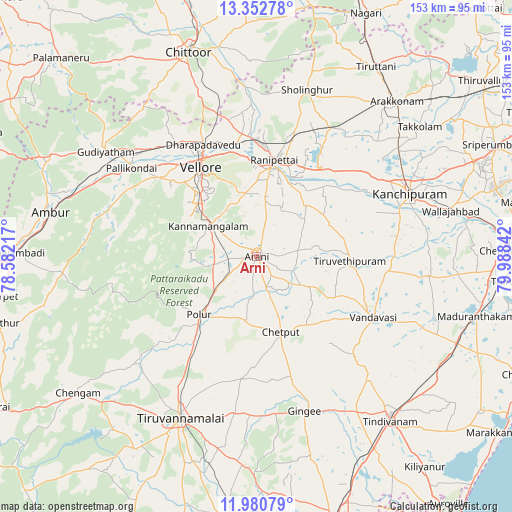
Arni GPS coordinates[2]
12° 40' 3.756" North, 79° 17' 7.044" East
| Map corner | latitude | longitude |
|---|---|---|
| Upper-left | 13.35278°, | 78.58217° |
| Center: | 12.66771°, | 79.28529° |
| Lower-right: | 11.98079°, | 79.98842° |
| Map W x H: | 152.6×152.6 km | = 94.8×94.8mi |
| max Lat: | 34.9274° ⇑87.9% North |
| Arni: | 12.66771° |
| min Lat: | ⇓12.1% South 8.09008° |
| min Long | Arni | max Long |
| 68.82655° | 79.28529° | 96.81° |
| W 61.7%⇐ | ⇒38.3% E |
Elevation
Elevation of Arni is 149 m = 489 ft, and this is 146.6 m = 481 ft below average elevation for this country.
| Max E: |
3681 m = 12077 ft | 59.9% |
| Avg. | 295.6 m = 970 ft | |
| Arni | 149 m = 489 ft | |
Min E: |
1 m = 3 ft | 40.1% |
See also: Arni elevation on elevation.city.
Geographical zone
Arni is located in North Torrid zone (between Equator and Tropic of Cancer). Distance of this Northern Tropic circle is 1197.4 km =744 mi to North.| Distance of | km | miles | from Arni |
|---|---|---|---|
| North Pole | 8598.5 | 5342.9 | to North |
| Arctic Circle | 5992.7 | 3723.7 | to North |
| Tropic Cancer | 1197.4 | 744 | to North |
| Equator | 1408.5 | 875.2 | to South |


Nearby cities:
15 places around Arni: (largest is in red/bold)
• Arcot
26.7 km =16.6 mi,  7°
7°
• Cheyyar
28 km =17.4 mi,  91°
91°
• Desūr
33.3 km =20.7 mi,  140°
140°
• Dūsi
44.4 km =27.6 mi,  74°
74°
• Kalavai
18.5 km =11.5 mi,  52°
52°
• Kātpādi
36.8 km =22.9 mi,  335°
335°
• Odugattūr
45 km =28 mi,  284°
284°
• Pallikondai
45.6 km =28.3 mi,  305°
305°
• Pennāthur
47.2 km =29.3 mi,  187°
187°
• Peranamallūr
19.4 km =12.1 mi,  123°
123°
• Polūr
24.6 km =15.3 mi,  225°
225°
• Pudūr
39.8 km =24.7 mi, 337°
• Vandavāsi
39.2 km =24.4 mi, 117°
• Vellore
32.4 km =20.1 mi,  329°
329°
• Walajapet
29.9 km =18.6 mi,  17°
17°
Sources, notices
• [Note1] Compared only with cities in India existing in our database
• [Src1] Map data: © OpenStreetMap contributors (CC-BY-SA)
• [Src2] Other city data from geonames.org with taken over terms of usage.
• [Src3] Geographical zone / Annual Mean Temperature by Robert A. Rohde @ Wikipedia
