Palmaner geodata
Palmaner (Andhra Pradesh) is a populated place; located in India in Asia/Kolkata (GMT+5.5) time zone. With population of 42,179 people, there are 1047 cities with bigger population in this country. Compared to other cities in India, 85.3% of cities are located further ↑North; 56.3% of cities are located further ←West and 91.7% of cities have lower elevation than Palmaner. Note1


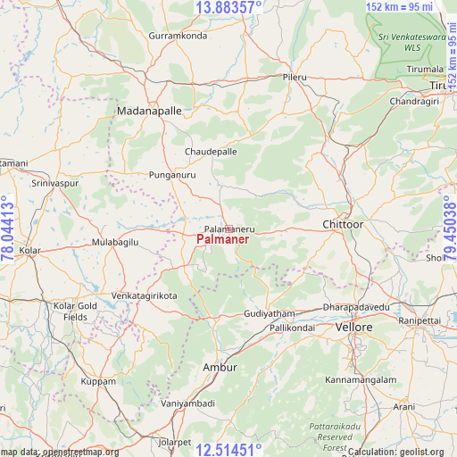
Palmaner GPS coordinates[2]
13° 12' 0" North, 78° 44' 50.1" East
| Map corner | latitude | longitude |
|---|---|---|
| Upper-left | 13.88357°, | 78.04413° |
| Center: | 13.2°, | 78.74725° |
| Lower-right: | 12.51451°, | 79.45038° |
| Map W x H: | 152.2×152.2 km | = 94.6×94.6mi |
| max Lat: | 34.9274° ⇑85.3% North |
| Palmaner: | 13.2° |
| min Lat: | ⇓14.7% South 8.09008° |
| min Long | Palmaner | max Long |
| 68.82655° | 78.74725° | 96.81° |
| W 56.3%⇐ | ⇒43.7% E |
Elevation
Elevation of Palmaner is 675 m = 2215 ft, and this is 379.4 m = 1245 ft above average elevation for this country.
| Max E: |
3681 m = 12077 ft | 8.3% |
| Palmaner | 675 m 2215 ft | |
| Avg. | 295.6 m = 970 ft | |
Min E: |
1 m = 3 ft | 91.7% |
See also: Palmaner elevation on elevation.city.
Geographical zone
Palmaner is located in North Torrid zone (between Equator and Tropic of Cancer). Distance of this Northern Tropic circle is 1138.2 km =707.2 mi to North.| Distance of | km | miles | from Palmaner |
|---|---|---|---|
| North Pole | 8539.4 | 5306.1 | to North |
| Arctic Circle | 5933.5 | 3686.9 | to North |
| Tropic Cancer | 1138.2 | 707.2 | to North |
| Equator | 1467.7 | 912 | to South |


Nearby cities:
15 places around Palmaner: (largest is in red/bold)
• Ambur
45.5 km =28.3 mi,  184°
184°
• Chittoor
37.7 km =23.4 mi,  88°
88°
• Gudiyatham
31.4 km =19.5 mi,  154°
154°
• Kātpādi
50.2 km =31.2 mi,  120°
120°
• Madanapalle
47.1 km =29.3 mi,  325°
325°
• Mulbāgal
38.5 km =23.9 mi,  263°
263°
• Odugattūr
50.2 km =31.2 mi,  162°
162°
• Pallikondai
39 km =24.2 mi, 147°
• Peranāmpattu
29.7 km =18.5 mi,  185°
185°
• Pudūr
48.4 km =30.1 mi, 117°
• Punganūru
26.5 km =16.5 mi,  314°
314°
• Pākāla
48.5 km =30.1 mi,  55°
55°
• Robertsonpet
57.8 km =35.9 mi,  242°
242°
• Rāmāpuram
48.6 km =30.2 mi,  103°
103°
• Vellore
52.2 km =32.4 mi,  126°
126°
Sources, notices
• [Note1] Compared only with cities in India existing in our database
• [Src1] Map data: © OpenStreetMap contributors (CC-BY-SA)
• [Src2] Other city data from geonames.org with taken over terms of usage.
• [Src3] Geographical zone / Annual Mean Temperature by Robert A. Rohde @ Wikipedia
