Pudūr geodata
Pudūr (Tamil Nadu) is a populated place; located in India in Asia/Kolkata (GMT+5.5) time zone. With population of 8,281 people, there are 3103 cities with bigger population in this country. Compared to other cities in India, 98.2% of cities are located further ↑North; 50.5% of cities are located further ←West and 77% of cities have higher elevation than Pudūr. Note1


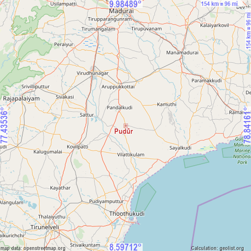
Pudūr GPS coordinates[2]
9° 17' 30.084" North, 78° 8' 18.528" East
| Map corner | latitude | longitude |
|---|---|---|
| Upper-left | 9.98489°, | 77.43536° |
| Center: | 9.29169°, | 78.13848° |
| Lower-right: | 8.59712°, | 78.84161° |
| Map W x H: | 154.3×154.3 km | = 95.9×95.9mi |
| max Lat: | 34.9274° ⇑98.2% North |
| Pudūr: | 9.29169° |
| min Lat: | ⇓1.8% South 8.09008° |
| min Long | Pudūr | max Long |
| 68.82655° | 78.13848° | 96.81° |
| W 50.5%⇐ | ⇒49.5% E |
Elevation
Elevation of Pudūr is 59 m = 194 ft, and this is 236.6 m = 776 ft below average elevation for this country.
| Max E: |
3681 m = 12077 ft | 77% |
| Avg. | 295.6 m = 970 ft | |
| Pudūr | 59 m = 194 ft | |
Min E: |
1 m = 3 ft | 23% |
See also: India elevation on elevation.city.
Geographical zone
Pudūr is located in North Torrid zone (between Equator and Tropic of Cancer). Distance of Equator is 1033.1 km =641.9 mi to South.| Distance of | km | miles | from Pudūr |
|---|---|---|---|
| North Pole | 8973.9 | 5576.1 | to North |
| Arctic Circle | 6368 | 3956.9 | to North |
| Tropic Cancer | 1572.8 | 977.3 | to North |
| Equator | 1033.1 | 641.9 | to South |


Nearby cities:
15 places around Pudūr: (largest is in red/bold)
• Abirāmam
37.1 km =23.1 mi,  63°
63°
• Aruppukkottai
24.7 km =15.3 mi,  349°
349°
• Elāyirampannai
34.5 km =21.4 mi,  266°
266°
• Ettaiyapuram
23.1 km =14.4 mi,  224°
224°
• Kamuthi
28.8 km =17.9 mi, 63°
• Kariapatti
42.8 km =26.6 mi, 354°
• Kovilpatti
32.4 km =20.1 mi,  245°
245°
• Kulattūr
32.6 km =20.3 mi,  169°
169°
• Mudukulattūr
41.6 km =25.8 mi,  82°
82°
• Sattur
24.5 km =15.2 mi,  286°
286°
• Sivakasi
41.3 km =25.7 mi,  295°
295°
• Sāyalkudi
36.5 km =22.7 mi,  111°
111°
• Tiruttangal
39.7 km =24.7 mi, 302°
• Vilattikulam
18 km =11.2 mi, 170°
• Virudunagar
38.2 km =23.7 mi,  328°
328°
Sources, notices
• [Note1] Compared only with cities in India existing in our database
• [Src1] Map data: © OpenStreetMap contributors (CC-BY-SA)
• [Src2] Other city data from geonames.org with taken over terms of usage.
• [Src3] Geographical zone / Annual Mean Temperature by Robert A. Rohde @ Wikipedia
