Kamuthi geodata
Kamuthi (Tamil Nadu) is a populated place; located in India in Asia/Kolkata (GMT+5.5) time zone. With population of 13,342 people, there are 2624 cities with bigger population in this country. Compared to other cities in India, 97.9% of cities are located further ↑North; 52.8% of cities are located further ←West and 84.2% of cities have higher elevation than Kamuthi. Note1


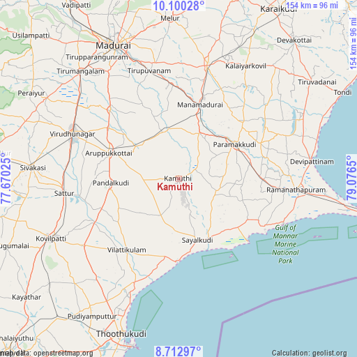
Kamuthi GPS coordinates[2]
9° 24' 26.352" North, 78° 22' 24.132" East
| Map corner | latitude | longitude |
|---|---|---|
| Upper-left | 10.10028°, | 77.67025° |
| Center: | 9.40732°, | 78.37337° |
| Lower-right: | 8.71297°, | 79.0765° |
| Map W x H: | 154.3×154.3 km | = 95.9×95.9mi |
| max Lat: | 34.9274° ⇑97.9% North |
| Kamuthi: | 9.40732° |
| min Lat: | ⇓2.1% South 8.09008° |
| min Long | Kamuthi | max Long |
| 68.82655° | 78.37337° | 96.81° |
| W 52.8%⇐ | ⇒47.2% E |
Elevation
Elevation of Kamuthi is 33 m = 108 ft, and this is 262.6 m = 862 ft below average elevation for this country.
| Max E: |
3681 m = 12077 ft | 84.2% |
| Avg. | 295.6 m = 970 ft | |
| Kamuthi | 33 m = 108 ft | |
Min E: |
1 m = 3 ft | 15.8% |
See also: India elevation on elevation.city.
Geographical zone
Kamuthi is located in North Torrid zone (between Equator and Tropic of Cancer). Distance of Equator is 1046 km =650 mi to South.| Distance of | km | miles | from Kamuthi |
|---|---|---|---|
| North Pole | 8961.1 | 5568.2 | to North |
| Arctic Circle | 6355.2 | 3948.9 | to North |
| Tropic Cancer | 1559.9 | 969.3 | to North |
| Equator | 1046 | 650 | to South |


Nearby cities:
15 places around Kamuthi: (largest is in red/bold)
• Abirāmam
8.3 km =5.2 mi,  61°
61°
• Aruppukkottai
32.5 km =20.2 mi,  290°
290°
• Kariapatti
42.3 km =26.3 mi,  314°
314°
• Keelakarai
49.2 km =30.6 mi,  113°
113°
• Kulattūr
49.1 km =30.5 mi,  203°
203°
• Manamadurai
31.4 km =19.5 mi,  19°
19°
• Mangalam
49.4 km =30.7 mi,  36°
36°
• Mudukulattūr
17.1 km =10.6 mi,  115°
115°
• Paramagudi
28.4 km =17.6 mi, 57°
• Pudūr
28.8 km =17.9 mi,  243°
243°
• Sattur
49.6 km =30.8 mi,  263°
263°
• Sāyalkudi
27.7 km =17.2 mi,  163°
163°
• Tiruppuvanam
48.2 km =30 mi,  344°
344°
• Vilattikulam
38.1 km =23.7 mi,  216°
216°
• Virudunagar
49.7 km =30.9 mi, 293°
Sources, notices
• [Note1] Compared only with cities in India existing in our database
• [Src1] Map data: © OpenStreetMap contributors (CC-BY-SA)
• [Src2] Other city data from geonames.org with taken over terms of usage.
• [Src3] Geographical zone / Annual Mean Temperature by Robert A. Rohde @ Wikipedia
