Aruppukkottai geodata
Aruppukkottai (Tamil Nadu) is a populated place; located in India in Asia/Kolkata (GMT+5.5) time zone. With population of 85,369 people, there are 523 cities with bigger population in this country. Compared to other cities in India, 97.7% of cities are located further ↑North; 50.3% of cities are located further →East and 68.5% of cities have higher elevation than Aruppukkottai. Note1


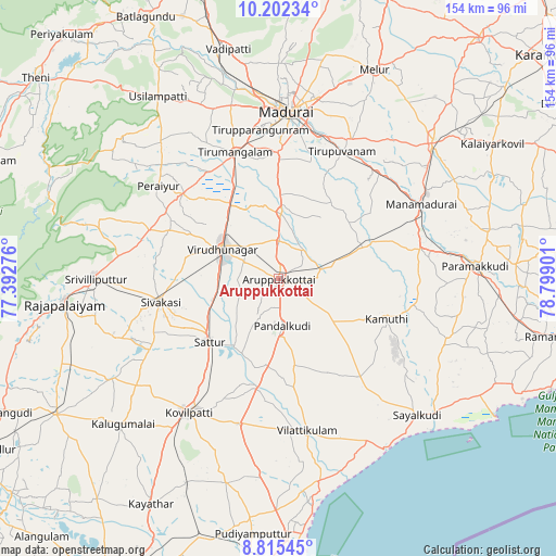
Aruppukkottai GPS coordinates[2]
9° 30' 34.56" North, 78° 5' 45.168" East
| Map corner | latitude | longitude |
|---|---|---|
| Upper-left | 10.20234°, | 77.39276° |
| Center: | 9.5096°, | 78.09588° |
| Lower-right: | 8.81545°, | 78.79901° |
| Map W x H: | 154.2×154.2 km | = 95.8×95.8mi |
| max Lat: | 34.9274° ⇑97.7% North |
| Aruppukkottai: | 9.5096° |
| min Lat: | ⇓2.3% South 8.09008° |
| min Long | Aruppukkottai | max Long |
| 68.82655° | 78.09588° | 96.81° |
| W 49.7%⇐ | ⇒50.3% E |
Elevation
Elevation of Aruppukkottai is 100 m = 328 ft, and this is 195.6 m = 642 ft below average elevation for this country.
| Max E: |
3681 m = 12077 ft | 68.5% |
| Avg. | 295.6 m = 970 ft | |
| Aruppukkottai | 100 m = 328 ft | |
Min E: |
1 m = 3 ft | 31.5% |
See also: Aruppukkottai elevation on elevation.city.
Geographical zone
Aruppukkottai is located in North Torrid zone (between Equator and Tropic of Cancer). Distance of Equator is 1057.4 km =657 mi to South.| Distance of | km | miles | from Aruppukkottai |
|---|---|---|---|
| North Pole | 8949.7 | 5561.1 | to North |
| Arctic Circle | 6343.8 | 3941.9 | to North |
| Tropic Cancer | 1548.6 | 962.3 | to North |
| Equator | 1057.4 | 657 | to South |


Nearby cities:
15 places around Aruppukkottai: (largest is in red/bold)
• Abirāmam
38.5 km =23.9 mi,  101°
101°
• Elāyirampannai
39.9 km =24.8 mi,  228°
228°
• Ettaiyapuram
42.3 km =26.3 mi,  195°
195°
• Kallupatti
34.1 km =21.2 mi,  312°
312°
• Kamuthi
32.5 km =20.2 mi,  110°
110°
• Kariapatti
18.4 km =11.4 mi,  1°
1°
• Peraiyur
42 km =26.1 mi, 306°
• Pudūr
24.7 km =15.3 mi,  169°
169°
• Sattur
25.4 km =15.8 mi, 227°
• Sivakasi
33.3 km =20.7 mi,  258°
258°
• Tirupparangunram
41.4 km =25.7 mi,  356°
356°
• Tiruppuvanam
39.4 km =24.5 mi,  26°
26°
• Tiruttangal
28.9 km =18 mi, 264°
• Vilattikulam
42.7 km =26.5 mi, 169°
• Virudunagar
17.3 km =10.7 mi,  299°
299°
Sources, notices
• [Note1] Compared only with cities in India existing in our database
• [Src1] Map data: © OpenStreetMap contributors (CC-BY-SA)
• [Src2] Other city data from geonames.org with taken over terms of usage.
• [Src3] Geographical zone / Annual Mean Temperature by Robert A. Rohde @ Wikipedia
