Pratāpgarh geodata
Pratāpgarh (Rajasthan) is a populated place; located in India in Asia/Kolkata (GMT+5.5) time zone. With population of 37,780 people, there are 1168 cities with bigger population in this country. Compared to other cities in India, 58.3% of cities are located further ↓South; 84.5% of cities are located further →East and 82.3% of cities have lower elevation than Pratāpgarh. Note1


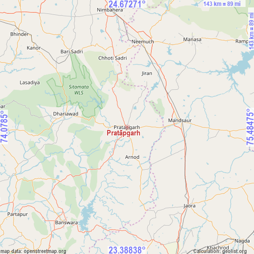
Pratāpgarh GPS coordinates[2]
24° 1' 55.74" North, 74° 46' 53.832" East
| Map corner | latitude | longitude |
|---|---|---|
| Upper-left | 24.67271°, | 74.0785° |
| Center: | 24.03215°, | 74.78162° |
| Lower-right: | 23.38838°, | 75.48475° |
| Map W x H: | 142.8×142.8 km | = 88.7×88.7mi |
| max Lat: | 34.9274° ⇑41.7% North |
| Pratāpgarh: | 24.03215° |
| min Lat: | ⇓58.3% South 8.09008° |
| min Long | Pratāpgarh | max Long |
| 68.82655° | 74.78162° | 96.81° |
| W 15.5%⇐ | ⇒84.5% E |
Elevation
Elevation of Pratāpgarh is 498 m = 1634 ft, and this is 202.4 m = 664 ft above average elevation for this country.
| Max E: |
3681 m = 12077 ft | 17.7% |
| Pratāpgarh | 498 m 1634 ft | |
| Avg. | 295.6 m = 970 ft | |
Min E: |
1 m = 3 ft | 82.3% |
See also: India elevation on elevation.city.
Geographical zone
Pratāpgarh is located in North temperate zone (between Tropic of Cancer and the Arctic Circle). Distance of this Northern Tropic circle is 66.2 km =41.1 mi to South.| Distance of | km | miles | from Pratāpgarh |
|---|---|---|---|
| North Pole | 7334.9 | 4557.7 | to North |
| Arctic Circle | 4729 | 2938.5 | to North |
| Tropic Cancer | 66.2 | 41.1 | to South |
| Equator | 2672.1 | 1660.4 | to South |


Nearby cities:
15 places around Pratāpgarh: (largest is in red/bold)
• Bari Sādri
52.7 km =32.7 mi,  323°
323°
• Bānswāra
64.6 km =40.1 mi,  212°
212°
• Chhoti Sādri
39.7 km =24.7 mi,  348°
348°
• Jaorā
56.2 km =34.9 mi,  141°
141°
• Jāwad
63.6 km =39.5 mi,  7°
7°
• Jīran
32.7 km =20.3 mi,  19°
19°
• Kānor
68.8 km =42.8 mi,  310°
310°
• Malhārgarh
35 km =21.7 mi,  37°
37°
• Mandsaur
29.6 km =18.4 mi,  81°
81°
• Manāsa
61.5 km =38.2 mi, 36°
• Neemuch
50.1 km =31.1 mi, 9°
• Nārāyangarh
38 km =23.6 mi,  45°
45°
• Nīmbāhera
66.4 km =41.3 mi, 351°
• Sailāna
65 km =40.4 mi,  167°
167°
• Sītāmau
58.1 km =36.1 mi,  91°
91°
Sources, notices
• [Note1] Compared only with cities in India existing in our database
• [Src1] Map data: © OpenStreetMap contributors (CC-BY-SA)
• [Src2] Other city data from geonames.org with taken over terms of usage.
• [Src3] Geographical zone / Annual Mean Temperature by Robert A. Rohde @ Wikipedia
