Sītāmau geodata
Sītāmau (Madhya Pradesh) is a populated place; located in India in Asia/Kolkata (GMT+5.5) time zone. With population of 13,441 people, there are 2617 cities with bigger population in this country. Compared to other cities in India, 58.2% of cities are located further ↓South; 79.7% of cities are located further →East and 81.6% of cities have lower elevation than Sītāmau. Note1


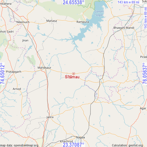
Sītāmau GPS coordinates[2]
24° 0' 53.028" North, 75° 21' 11.664" East
| Map corner | latitude | longitude |
|---|---|---|
| Upper-left | 24.65538°, | 74.65012° |
| Center: | 24.01473°, | 75.35324° |
| Lower-right: | 23.37087°, | 76.05637° |
| Map W x H: | 142.8×142.8 km | = 88.7×88.7mi |
| max Lat: | 34.9274° ⇑41.8% North |
| Sītāmau: | 24.01473° |
| min Lat: | ⇓58.2% South 8.09008° |
| min Long | Sītāmau | max Long |
| 68.82655° | 75.35324° | 96.81° |
| W 20.3%⇐ | ⇒79.7% E |
Elevation
Elevation of Sītāmau is 484 m = 1588 ft, and this is 188.4 m = 618 ft above average elevation for this country.
| Max E: |
3681 m = 12077 ft | 18.4% |
| Sītāmau | 484 m 1588 ft | |
| Avg. | 295.6 m = 970 ft | |
Min E: |
1 m = 3 ft | 81.6% |
See also: India elevation on elevation.city.
Geographical zone
Sītāmau is located in North temperate zone (between Tropic of Cancer and the Arctic Circle). Distance of this Northern Tropic circle is 64.3 km =40 mi to South.| Distance of | km | miles | from Sītāmau |
|---|---|---|---|
| North Pole | 7336.9 | 4558.9 | to North |
| Arctic Circle | 4731 | 2939.7 | to North |
| Tropic Cancer | 64.3 | 40 | to South |
| Equator | 2670.2 | 1659.2 | to South |


Nearby cities:
15 places around Sītāmau: (largest is in red/bold)
• Alot
34.8 km =21.6 mi,  143°
143°
• Bhawāniganj
66.2 km =41.1 mi,  47°
47°
• Gogāpur
53.5 km =33.2 mi,  161°
161°
• Jaorā
47.8 km =29.7 mi,  208°
208°
• Jīran
57.2 km =35.5 mi,  304°
304°
• Khāchrod
66.2 km =41.1 mi,  186°
186°
• Malhārgarh
47.4 km =29.5 mi,  308°
308°
• Mandsaur
29.5 km =18.3 mi,  282°
282°
• Manāsa
55.8 km =34.7 mi,  337°
337°
• Nagda
62.2 km =38.6 mi,  173°
173°
• Nārāyangarh
41.9 km =26 mi, 312°
• Pratāpgarh
58.1 km =36.1 mi,  271°
271°
• Rāmpura
51.1 km =31.8 mi,  9°
9°
• Shāmgarh
34.8 km =21.6 mi,  56°
56°
• Tāl
33 km =20.5 mi, 174°
Sources, notices
• [Note1] Compared only with cities in India existing in our database
• [Src1] Map data: © OpenStreetMap contributors (CC-BY-SA)
• [Src2] Other city data from geonames.org with taken over terms of usage.
• [Src3] Geographical zone / Annual Mean Temperature by Robert A. Rohde @ Wikipedia
