Jāwad geodata
Jāwad (Madhya Pradesh) is a populated place; located in India in Asia/Kolkata (GMT+5.5) time zone. With population of 16,887 people, there are 2295 cities with bigger population in this country. Compared to other cities in India, 61.3% of cities are located further ↓South; 83.8% of cities are located further →East and 80.5% of cities have lower elevation than Jāwad. Note1


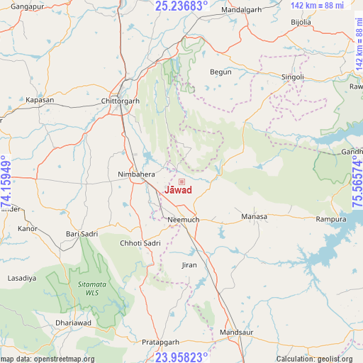
Jāwad GPS coordinates[2]
24° 35' 56.976" North, 74° 51' 45.396" East
| Map corner | latitude | longitude |
|---|---|---|
| Upper-left | 25.23683°, | 74.15949° |
| Center: | 24.59916°, | 74.86261° |
| Lower-right: | 23.95823°, | 75.56574° |
| Map W x H: | 142.2×142.2 km | = 88.4×88.4mi |
| max Lat: | 34.9274° ⇑38.7% North |
| Jāwad: | 24.59916° |
| min Lat: | ⇓61.3% South 8.09008° |
| min Long | Jāwad | max Long |
| 68.82655° | 74.86261° | 96.81° |
| W 16.2%⇐ | ⇒83.8% E |
Elevation
Elevation of Jāwad is 467 m = 1532 ft, and this is 171.4 m = 562 ft above average elevation for this country.
| Max E: |
3681 m = 12077 ft | 19.5% |
| Jāwad | 467 m 1532 ft | |
| Avg. | 295.6 m = 970 ft | |
Min E: |
1 m = 3 ft | 80.5% |
See also: India elevation on elevation.city.
Geographical zone
Jāwad is located in North temperate zone (between Tropic of Cancer and the Arctic Circle). Distance of this Northern Tropic circle is 129.3 km =80.3 mi to South.| Distance of | km | miles | from Jāwad |
|---|---|---|---|
| North Pole | 7271.9 | 4518.5 | to North |
| Arctic Circle | 4666 | 2899.3 | to North |
| Tropic Cancer | 129.3 | 80.3 | to South |
| Equator | 2735.2 | 1699.6 | to South |


Nearby cities:
15 places around Jāwad: (largest is in red/bold)
• Bari Sādri
44.5 km =27.7 mi,  242°
242°
• Begūn
44.9 km =27.9 mi,  17°
17°
• Chhoti Sādri
29.2 km =18.1 mi,  214°
214°
• Chittaurgarh
40.3 km =25 mi,  323°
323°
• Jīran
32.4 km =20.1 mi,  174°
174°
• Kānor
63.1 km =39.2 mi,  253°
253°
• Malhārgarh
37.5 km =23.3 mi,  159°
159°
• Mandsaur
62.3 km =38.7 mi, 160°
• Manāsa
31.2 km =19.4 mi,  115°
115°
• Neemuch
13.7 km =8.5 mi,  180°
180°
• Nārāyangarh
41.1 km =25.5 mi,  152°
152°
• Nīmbāhera
18.6 km =11.6 mi,  277°
277°
• Ratangarh
35.3 km =21.9 mi,  46°
46°
• Rāmpura
60.2 km =37.4 mi,  104°
104°
• Singoli
60.2 km =37.4 mi, 47°
Sources, notices
• [Note1] Compared only with cities in India existing in our database
• [Src1] Map data: © OpenStreetMap contributors (CC-BY-SA)
• [Src2] Other city data from geonames.org with taken over terms of usage.
• [Src3] Geographical zone / Annual Mean Temperature by Robert A. Rohde @ Wikipedia
