Mandsaur geodata
Mandsaur (Madhya Pradesh) is a populated place; located in India in Asia/Kolkata (GMT+5.5) time zone. With population of 124,988 people, there are 350 cities with bigger population in this country. Compared to other cities in India, 58.5% of cities are located further ↓South; 82.1% of cities are located further →East and 78.5% of cities have lower elevation than Mandsaur. Note1


Mandsaur GPS coordinates[2]
24° 4' 18.624" North, 75° 4' 11.496" East
| Map corner | latitude | longitude |
|---|---|---|
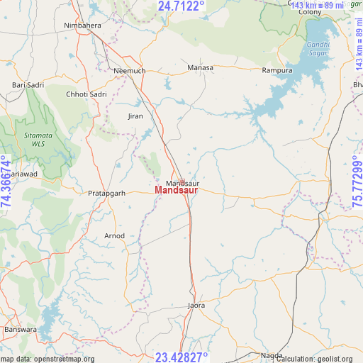
| Upper-left | 24.7122°, | 74.36674° |
| Center: | 24.07184°, | 75.06986° |
| Lower-right: | 23.42827°, | 75.77299° |
| Map W x H: | 142.8×142.8 km | = 88.7×88.7mi |
| max Lat: | 34.9274° ⇑41.5% North |
| Mandsaur: | 24.07184° |
| min Lat: | ⇓58.5% South 8.09008° |
| min Long | Mandsaur | max Long |
| 68.82655° | 75.06986° | 96.81° |
| W 17.9%⇐ | ⇒82.1% E |
Elevation
Elevation of Mandsaur is 440 m = 1444 ft, and this is 144.4 m = 474 ft above average elevation for this country.
| Max E: |
3681 m = 12077 ft | 21.5% |
| Mandsaur | 440 m 1444 ft | |
| Avg. | 295.6 m = 970 ft | |
Min E: |
1 m = 3 ft | 78.5% |
See also: Mandsaur elevation on elevation.city.
Geographical zone
Mandsaur is located in North temperate zone (between Tropic of Cancer and the Arctic Circle). Distance of this Northern Tropic circle is 70.6 km =43.9 mi to South.| Distance of | km | miles | from Mandsaur |
|---|---|---|---|
| North Pole | 7330.5 | 4555 | to North |
| Arctic Circle | 4724.6 | 2935.7 | to North |
| Tropic Cancer | 70.6 | 43.9 | to South |
| Equator | 2676.5 | 1663.1 | to South |


Nearby cities:
15 places around Mandsaur: (largest is in red/bold)
• Alot
60.2 km =37.4 mi,  124°
124°
• Chhoti Sādri
50.8 km =31.6 mi,  312°
312°
• Jaorā
48.6 km =30.2 mi,  173°
173°
• Jāwad
62.3 km =38.7 mi,  340°
340°
• Jīran
32 km =19.9 mi,  325°
325°
• Malhārgarh
24.8 km =15.4 mi, 341°
• Manāsa
45.7 km =28.4 mi,  9°
9°
• Namli
67.9 km =42.2 mi,  180°
180°
• Neemuch
49.7 km =30.9 mi, 334°
• Nārāyangarh
22.2 km =13.8 mi,  354°
354°
• Pratāpgarh
29.6 km =18.4 mi,  261°
261°
• Rāmpura
57.8 km =35.9 mi,  40°
40°
• Shāmgarh
59.2 km =36.8 mi,  77°
77°
• Sītāmau
29.5 km =18.3 mi,  102°
102°
• Tāl
50.6 km =31.4 mi,  140°
140°
Sources, notices
• [Note1] Compared only with cities in India existing in our database
• [Src1] Map data: © OpenStreetMap contributors (CC-BY-SA)
• [Src2] Other city data from geonames.org with taken over terms of usage.
• [Src3] Geographical zone / Annual Mean Temperature by Robert A. Rohde @ Wikipedia
