Neemuch geodata
Neemuch (Rajasthan) is a seat of a second-order administrative division; located in India in Asia/Kolkata (GMT+5.5) time zone. In our database, there are 3475 cities with bigger population. Compared to other cities in India, 60.5% of cities are located further ↓South; 83.8% of cities are located further →East and 81.9% of cities have lower elevation than Neemuch. Note1


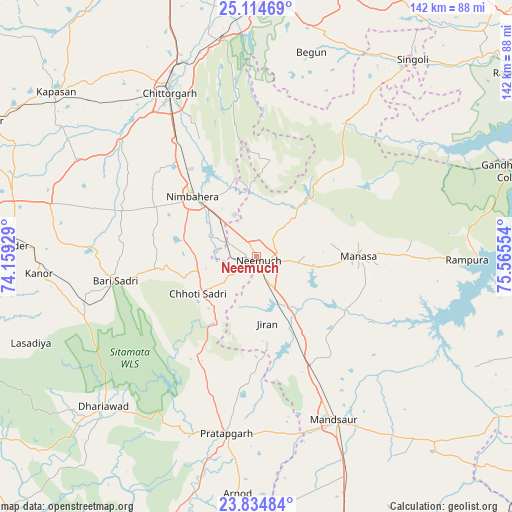
Neemuch GPS coordinates[2]
24° 28' 35.004" North, 74° 51' 44.676" East
| Map corner | latitude | longitude |
|---|---|---|
| Upper-left | 25.11469°, | 74.15929° |
| Center: | 24.47639°, | 74.86241° |
| Lower-right: | 23.83484°, | 75.56554° |
| Map W x H: | 142.3×142.3 km | = 88.4×88.4mi |
| max Lat: | 34.9274° ⇑39.5% North |
| Neemuch: | 24.47639° |
| min Lat: | ⇓60.5% South 8.09008° |
| min Long | Neemuch | max Long |
| 68.82655° | 74.86241° | 96.81° |
| W 16.2%⇐ | ⇒83.8% E |
Elevation
Elevation of Neemuch is 488 m = 1601 ft, and this is 192.4 m = 631 ft above average elevation for this country.
| Max E: |
3681 m = 12077 ft | 18.1% |
| Neemuch | 488 m 1601 ft | |
| Avg. | 295.6 m = 970 ft | |
Min E: |
1 m = 3 ft | 81.9% |
See also: India elevation on elevation.city.
Geographical zone
Neemuch is located in North temperate zone (between Tropic of Cancer and the Arctic Circle). Distance of this Northern Tropic circle is 115.6 km =71.8 mi to South.| Distance of | km | miles | from Neemuch |
|---|---|---|---|
| North Pole | 7285.5 | 4527 | to North |
| Arctic Circle | 4679.7 | 2907.8 | to North |
| Tropic Cancer | 115.6 | 71.8 | to South |
| Equator | 2721.5 | 1691.1 | to South |


Nearby cities:
15 places around Neemuch: (largest is in red/bold)
• Bari Sādri
40 km =24.9 mi,  259°
259°
• Begūn
58.1 km =36.1 mi,  13°
13°
• Chhoti Sādri
19.4 km =12.1 mi,  237°
237°
• Chittaurgarh
51.9 km =32.2 mi,  332°
332°
• Jāwad
13.7 km =8.5 mi,  0°
0°
• Jīran
18.9 km =11.7 mi,  171°
171°
• Kānor
60.6 km =37.7 mi,  265°
265°
• Malhārgarh
25.1 km =15.6 mi,  148°
148°
• Mandsaur
49.7 km =30.9 mi, 154°
• Manāsa
28.2 km =17.5 mi,  89°
89°
• Nārāyangarh
29.7 km =18.5 mi,  140°
140°
• Nīmbāhera
24.5 km =15.2 mi,  311°
311°
• Pratāpgarh
50.1 km =31.1 mi,  189°
189°
• Ratangarh
45.7 km =28.4 mi,  34°
34°
• Rāmpura
58.5 km =36.4 mi, 91°
Sources, notices
• [Note1] Compared only with cities in India existing in our database
• [Src1] Map data: © OpenStreetMap contributors (CC-BY-SA)
• [Src2] Other city data from geonames.org with taken over terms of usage.
• [Src3] Geographical zone / Annual Mean Temperature by Robert A. Rohde @ Wikipedia
