Sulya geodata
Sulya (Karnataka) is a populated place; located in India in Asia/Kolkata (GMT+5.5) time zone. With population of 18,950 people, there are 2132 cities with bigger population in this country. Compared to other cities in India, 88.3% of cities are located further ↑North; 79.3% of cities are located further →East and 65.2% of cities have higher elevation than Sulya. Note1


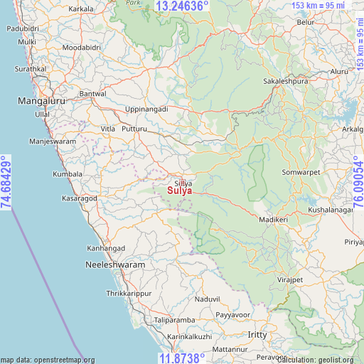
Sulya GPS coordinates[2]
12° 33' 39.6" North, 75° 23' 14.676" East
| Map corner | latitude | longitude |
|---|---|---|
| Upper-left | 13.24636°, | 74.68429° |
| Center: | 12.561°, | 75.38741° |
| Lower-right: | 11.8738°, | 76.09054° |
| Map W x H: | 152.6×152.6 km | = 94.8×94.8mi |
| max Lat: | 34.9274° ⇑88.3% North |
| Sulya: | 12.561° |
| min Lat: | ⇓11.7% South 8.09008° |
| min Long | Sulya | max Long |
| 68.82655° | 75.38741° | 96.81° |
| W 20.7%⇐ | ⇒79.3% E |
Elevation
Elevation of Sulya is 119 m = 390 ft, and this is 176.6 m = 579 ft below average elevation for this country.
| Max E: |
3681 m = 12077 ft | 65.2% |
| Avg. | 295.6 m = 970 ft | |
| Sulya | 119 m = 390 ft | |
Min E: |
1 m = 3 ft | 34.8% |
See also: India elevation on elevation.city.
Geographical zone
Sulya is located in North Torrid zone (between Equator and Tropic of Cancer). Distance of this Northern Tropic circle is 1209.3 km =751.4 mi to North.| Distance of | km | miles | from Sulya |
|---|---|---|---|
| North Pole | 8610.4 | 5350.3 | to North |
| Arctic Circle | 6004.5 | 3731 | to North |
| Tropic Cancer | 1209.3 | 751.4 | to North |
| Equator | 1396.7 | 867.9 | to South |


Nearby cities:
15 places around Sulya: (largest is in red/bold)
• Bantvāl
53 km =32.9 mi,  313°
313°
• Kodlipet
60.4 km =37.5 mi,  63°
63°
• Kānnangād
41.5 km =25.8 mi,  227°
227°
• Kāsaragod
43.7 km =27.2 mi,  260°
260°
• Madikeri
40.9 km =25.4 mi,  111°
111°
• Manjēshvar
56.7 km =35.2 mi,  287°
287°
• Nīlēshwar
43.3 km =26.9 mi,  219°
219°
• Payyannūr
55.7 km =34.6 mi,  201°
201°
• Puttūr
29.9 km =18.6 mi,  317°
317°
• Sakleshpur
60.4 km =37.5 mi,  45°
45°
• Sanivārsante
57.3 km =35.6 mi,  71°
71°
• Somvārpet
50.3 km =31.3 mi,  85°
85°
• Suntikoppa
49.4 km =30.7 mi,  103°
103°
• Talipparamba
57.8 km =35.9 mi,  183°
183°
• Vīrarājendrapet
60.8 km =37.8 mi,  131°
131°
Sources, notices
• [Note1] Compared only with cities in India existing in our database
• [Src1] Map data: © OpenStreetMap contributors (CC-BY-SA)
• [Src2] Other city data from geonames.org with taken over terms of usage.
• [Src3] Geographical zone / Annual Mean Temperature by Robert A. Rohde @ Wikipedia
