Kāsaragod geodata
Kāsaragod (Kerala) is a populated place; located in India in Asia/Kolkata (GMT+5.5) time zone. With population of 53,309 people, there are 834 cities with bigger population in this country. Compared to other cities in India, 88.6% of cities are located further ↑North; 83% of cities are located further →East and 81.4% of cities have higher elevation than Kāsaragod. Note1


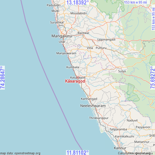
Kāsaragod GPS coordinates[2]
12° 29' 54.168" North, 74° 59' 22.524" East
| Map corner | latitude | longitude |
|---|---|---|
| Upper-left | 13.18392°, | 74.28647° |
| Center: | 12.49838°, | 74.98959° |
| Lower-right: | 11.81102°, | 75.69272° |
| Map W x H: | 152.7×152.7 km | = 94.9×94.9mi |
| max Lat: | 34.9274° ⇑88.6% North |
| Kāsaragod: | 12.49838° |
| min Lat: | ⇓11.4% South 8.09008° |
| min Long | Kāsaragod | max Long |
| 68.82655° | 74.98959° | 96.81° |
| W 17%⇐ | ⇒83% E |
Elevation
Elevation of Kāsaragod is 43 m = 141 ft, and this is 252.6 m = 829 ft below average elevation for this country.
| Max E: |
3681 m = 12077 ft | 81.4% |
| Avg. | 295.6 m = 970 ft | |
| Kāsaragod | 43 m = 141 ft | |
Min E: |
1 m = 3 ft | 18.6% |
See also: Kāsaragod elevation on elevation.city.
Geographical zone
Kāsaragod is located in North Torrid zone (between Equator and Tropic of Cancer). Distance of this Northern Tropic circle is 1216.2 km =755.7 mi to North.| Distance of | km | miles | from Kāsaragod |
|---|---|---|---|
| North Pole | 8617.4 | 5354.6 | to North |
| Arctic Circle | 6011.5 | 3735.4 | to North |
| Tropic Cancer | 1216.2 | 755.7 | to North |
| Equator | 1389.7 | 863.5 | to South |


Nearby cities:
15 places around Kāsaragod: (largest is in red/bold)
• Azhikkal
75.6 km =47 mi,  149°
149°
• Bantvāl
43.9 km =27.3 mi,  6°
6°
• Kānnangād
24.7 km =15.3 mi, 149°
• Kārkala
79.6 km =49.5 mi,  0°
0°
• Mangalore
48.8 km =30.3 mi,  342°
342°
• Manjēshvar
26.2 km =16.3 mi, 335°
• Mūdbidri
63.2 km =39.3 mi, 0°
• Mūlki
69.2 km =43 mi, 342°
• Nīlēshwar
30.9 km =19.2 mi, 149°
• Payyannūr
50.6 km =31.4 mi, 152°
• Puttūr
37.1 km =23.1 mi,  38°
38°
• Pāppinisshēri
71.3 km =44.3 mi, 147°
• Sulya
43.7 km =27.2 mi,  80°
80°
• Talipparamba
64.8 km =40.3 mi,  141°
141°
• Ullal
36.9 km =22.9 mi, 337°
Sources, notices
• [Note1] Compared only with cities in India existing in our database
• [Src1] Map data: © OpenStreetMap contributors (CC-BY-SA)
• [Src2] Other city data from geonames.org with taken over terms of usage.
• [Src3] Geographical zone / Annual Mean Temperature by Robert A. Rohde @ Wikipedia
