Sadāseopet geodata
Sadāseopet (Telangana) is a populated place; located in India in Asia/Kolkata (GMT+5.5) time zone. With population of 37,245 people, there are 1181 cities with bigger population in this country. Compared to other cities in India, 72.8% of cities are located further ↑North; 51.7% of cities are located further →East and 85% of cities have lower elevation than Sadāseopet. Note1


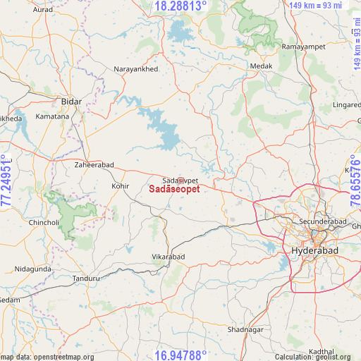
Sadāseopet GPS coordinates[2]
17° 37' 9.3" North, 77° 57' 9.468" East
| Map corner | latitude | longitude |
|---|---|---|
| Upper-left | 18.28813°, | 77.24951° |
| Center: | 17.61925°, | 77.95263° |
| Lower-right: | 16.94788°, | 78.65576° |
| Map W x H: | 149×149 km | = 92.6×92.6mi |
| max Lat: | 34.9274° ⇑72.8% North |
| Sadāseopet: | 17.61925° |
| min Lat: | ⇓27.2% South 8.09008° |
| min Long | Sadāseopet | max Long |
| 68.82655° | 77.95263° | 96.81° |
| W 48.3%⇐ | ⇒51.7% E |
Elevation
Elevation of Sadāseopet is 550 m = 1804 ft, and this is 254.4 m = 835 ft above average elevation for this country.
| Max E: |
3681 m = 12077 ft | 15% |
| Sadāseopet | 550 m 1804 ft | |
| Avg. | 295.6 m = 970 ft | |
Min E: |
1 m = 3 ft | 85% |
See also: India elevation on elevation.city.
Geographical zone
Sadāseopet is located in North Torrid zone (between Equator and Tropic of Cancer). Distance of this Northern Tropic circle is 646.8 km =401.9 mi to North.| Distance of | km | miles | from Sadāseopet |
|---|---|---|---|
| North Pole | 8048 | 5000.8 | to North |
| Arctic Circle | 5442.1 | 3381.6 | to North |
| Tropic Cancer | 646.8 | 401.9 | to North |
| Equator | 1959.1 | 1217.3 | to South |


Nearby cities:
15 places around Sadāseopet: (largest is in red/bold)
• Andol
25.4 km =15.8 mi,  31°
31°
• Bīdar
55.4 km =34.4 mi,  306°
306°
• Chandūr
32.4 km =20.1 mi, 28°
• Kūkatpalli
51.1 km =31.8 mi,  106°
106°
• Medak
57.5 km =35.7 mi, 34°
• Medchal
56 km =34.8 mi,  88°
88°
• Patancheru
34.4 km =21.4 mi, 106°
• Quthbullapur
55.2 km =34.3 mi,  103°
103°
• Sangāreddi
14.2 km =8.8 mi, 87°
• Serilingampalle
39.6 km =24.6 mi, 110°
• Singāpur
24.8 km =15.4 mi,  132°
132°
• Srīrāmnagar
50.7 km =31.5 mi,  140°
140°
• Tāndūr
57.3 km =35.6 mi,  224°
224°
• Vikārābād
31.7 km =19.7 mi,  189°
189°
• Zahirābād
37.2 km =23.1 mi,  280°
280°
Sources, notices
• [Note1] Compared only with cities in India existing in our database
• [Src1] Map data: © OpenStreetMap contributors (CC-BY-SA)
• [Src2] Other city data from geonames.org with taken over terms of usage.
• [Src3] Geographical zone / Annual Mean Temperature by Robert A. Rohde @ Wikipedia
