Pāppārappatti geodata
Pāppārappatti (Tamil Nadu) is a populated place; located in India in Asia/Kolkata (GMT+5.5) time zone. With population of 11,617 people, there are 2773 cities with bigger population in this country. Compared to other cities in India, 89.3% of cities are located further ↑North; 50.8% of cities are located further →East and 82.2% of cities have lower elevation than Pāppārappatti. Note1


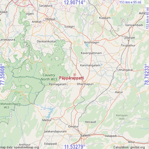
Pāppārappatti GPS coordinates[2]
12° 13' 15.096" North, 78° 3' 33.12" East
| Map corner | latitude | longitude |
|---|---|---|
| Upper-left | 12.90714°, | 77.35608° |
| Center: | 12.22086°, | 78.0592° |
| Lower-right: | 11.53279°, | 78.76233° |
| Map W x H: | 152.8×152.8 km | = 94.9×94.9mi |
| max Lat: | 34.9274° ⇑89.3% North |
| Pāppārappatti: | 12.22086° |
| min Lat: | ⇓10.7% South 8.09008° |
| min Long | Pāppārappatti | max Long |
| 68.82655° | 78.0592° | 96.81° |
| W 49.2%⇐ | ⇒50.8% E |
Elevation
Elevation of Pāppārappatti is 496 m = 1627 ft, and this is 200.4 m = 657 ft above average elevation for this country.
| Max E: |
3681 m = 12077 ft | 17.8% |
| Pāppārappatti | 496 m 1627 ft | |
| Avg. | 295.6 m = 970 ft | |
Min E: |
1 m = 3 ft | 82.2% |
See also: India elevation on elevation.city.
Geographical zone
Pāppārappatti is located in North Torrid zone (between Equator and Tropic of Cancer). Distance of this Northern Tropic circle is 1247.1 km =774.9 mi to North.| Distance of | km | miles | from Pāppārappatti |
|---|---|---|---|
| North Pole | 8648.2 | 5373.7 | to North |
| Arctic Circle | 6042.3 | 3754.5 | to North |
| Tropic Cancer | 1247.1 | 774.9 | to North |
| Equator | 1358.8 | 844.3 | to South |


Nearby cities:
15 places around Pāppārappatti: (largest is in red/bold)
• Denkanikota
45.2 km =28.1 mi,  319°
319°
• Dharmapuri
14.9 km =9.3 mi,  133°
133°
• Harūr
49.4 km =30.7 mi,  112°
112°
• Kelamangalam
48.1 km =29.9 mi,  332°
332°
• Krishnagiri
37.2 km =23.1 mi,  26°
26°
• Kunnattūr
51 km =31.7 mi,  73°
73°
• Kāveripatnam
28.3 km =17.6 mi,  37°
37°
• Mallāpuram
33.5 km =20.8 mi,  142°
142°
• Mārāndahalli
19.6 km =12.2 mi,  341°
341°
• Nangavalli
54.2 km =33.7 mi,  199°
199°
• Omalur
53.4 km =33.2 mi,  181°
181°
• Pallippatti
48.6 km =30.2 mi, 130°
• Pennāgaram
20.3 km =12.6 mi,  241°
241°
• Pālakkodu
9.6 km =6 mi,  7°
7°
• Pāpireddippatti
47.6 km =29.6 mi, 135°
Sources, notices
• [Note1] Compared only with cities in India existing in our database
• [Src1] Map data: © OpenStreetMap contributors (CC-BY-SA)
• [Src2] Other city data from geonames.org with taken over terms of usage.
• [Src3] Geographical zone / Annual Mean Temperature by Robert A. Rohde @ Wikipedia
