Harūr geodata
Harūr (Tamil Nadu) is a populated place; located in India in Asia/Kolkata (GMT+5.5) time zone. With population of 20,405 people, there are 2009 cities with bigger population in this country. Compared to other cities in India, 89.6% of cities are located further ↑North; 53.9% of cities are located further ←West and 72.1% of cities have lower elevation than Harūr. Note1


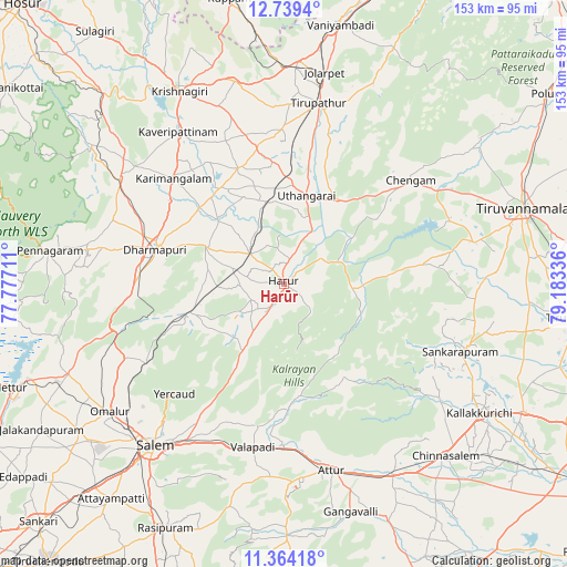
Harūr GPS coordinates[2]
12° 3' 9.612" North, 78° 28' 48.828" East
| Map corner | latitude | longitude |
|---|---|---|
| Upper-left | 12.7394°, | 77.77711° |
| Center: | 12.05267°, | 78.48023° |
| Lower-right: | 11.36418°, | 79.18336° |
| Map W x H: | 152.9×152.9 km | = 95×95mi |
| max Lat: | 34.9274° ⇑89.6% North |
| Harūr: | 12.05267° |
| min Lat: | ⇓10.4% South 8.09008° |
| min Long | Harūr | max Long |
| 68.82655° | 78.48023° | 96.81° |
| W 53.9%⇐ | ⇒46.1% E |
Elevation
Elevation of Harūr is 350 m = 1148 ft, and this is 54.4 m = 178 ft above average elevation for this country.
| Max E: |
3681 m = 12077 ft | 27.9% |
| Harūr | 350 m 1148 ft | |
| Avg. | 295.6 m = 970 ft | |
Min E: |
1 m = 3 ft | 72.1% |
See also: India elevation on elevation.city.
Geographical zone
Harūr is located in North Torrid zone (between Equator and Tropic of Cancer). Distance of this Northern Tropic circle is 1265.8 km =786.5 mi to North.| Distance of | km | miles | from Harūr |
|---|---|---|---|
| North Pole | 8666.9 | 5385.4 | to North |
| Arctic Circle | 6061 | 3766.1 | to North |
| Tropic Cancer | 1265.8 | 786.5 | to North |
| Equator | 1340.1 | 832.7 | to South |


Nearby cities:
15 places around Harūr: (largest is in red/bold)
• Alagāpuram
51 km =31.7 mi,  111°
111°
• Attur
52.7 km =32.7 mi,  165°
165°
• Belūr
39 km =24.2 mi,  190°
190°
• Chengam
44.2 km =27.5 mi,  49°
49°
• Dharmapuri
36 km =22.4 mi,  283°
283°
• Jalārpet
58.4 km =36.3 mi,  9°
9°
• Kunnattūr
33 km =20.5 mi, 5°
• Kāveripatnam
49.9 km =31 mi,  325°
325°
• Mallāpuram
26.4 km =16.4 mi,  252°
252°
• Omalur
58.6 km =36.4 mi,  233°
233°
• Pallippatti
15.2 km =9.4 mi,  214°
214°
• Pālakkodu
52.8 km =32.8 mi,  302°
302°
• Pāpireddippatti
19.3 km =12 mi,  218°
218°
• Pāppārappatti
49.4 km =30.7 mi,  292°
292°
• Salem
56.7 km =35.2 mi, 218°
Sources, notices
• [Note1] Compared only with cities in India existing in our database
• [Src1] Map data: © OpenStreetMap contributors (CC-BY-SA)
• [Src2] Other city data from geonames.org with taken over terms of usage.
• [Src3] Geographical zone / Annual Mean Temperature by Robert A. Rohde @ Wikipedia
