Denkanikota geodata
Denkanikota (Tamil Nadu) is a populated place; located in India in Asia/Kolkata (GMT+5.5) time zone. With population of 19,358 people, there are 2093 cities with bigger population in this country. Compared to other cities in India, 88.4% of cities are located further ↑North; 53.8% of cities are located further →East and 95.1% of cities have lower elevation than Denkanikota. Note1


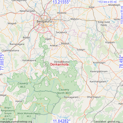
Denkanikota GPS coordinates[2]
12° 31' 48.36" North, 77° 47' 19.932" East
| Map corner | latitude | longitude |
|---|---|---|
| Upper-left | 13.21555°, | 77.08575° |
| Center: | 12.5301°, | 77.78887° |
| Lower-right: | 11.84282°, | 78.492° |
| Map W x H: | 152.6×152.6 km | = 94.8×94.8mi |
| max Lat: | 34.9274° ⇑88.4% North |
| Denkanikota: | 12.5301° |
| min Lat: | ⇓11.6% South 8.09008° |
| min Long | Denkanikota | max Long |
| 68.82655° | 77.78887° | 96.81° |
| W 46.2%⇐ | ⇒53.8% E |
Elevation
Elevation of Denkanikota is 886 m = 2907 ft, and this is 590.4 m = 1937 ft above average elevation for this country.
| Max E: |
3681 m = 12077 ft | 4.9% |
| Denkanikota | 886 m 2907 ft | |
| Avg. | 295.6 m = 970 ft | |
Min E: |
1 m = 3 ft | 95.1% |
See also: India elevation on elevation.city.
Geographical zone
Denkanikota is located in North Torrid zone (between Equator and Tropic of Cancer). Distance of this Northern Tropic circle is 1212.7 km =753.5 mi to North.| Distance of | km | miles | from Denkanikota |
|---|---|---|---|
| North Pole | 8613.8 | 5352.4 | to North |
| Arctic Circle | 6008 | 3733.2 | to North |
| Tropic Cancer | 1212.7 | 753.5 | to North |
| Equator | 1393.2 | 865.7 | to South |


Nearby cities:
15 places around Denkanikota: (largest is in red/bold)
• Anekal
22.5 km =14 mi,  333°
333°
• Bengaluru
53.5 km =33.2 mi,  336°
336°
• Closepet
59 km =36.7 mi,  291°
291°
• Dharmapuri
60.1 km =37.3 mi,  138°
138°
• Hoskote
60.1 km =37.3 mi,  0°
0°
• Hosūr
23.4 km =14.5 mi,  11°
11°
• Kelamangalam
10.6 km =6.6 mi,  40°
40°
• Krishnagiri
46.1 km =28.6 mi,  91°
91°
• Kānkānhalli
40.1 km =24.9 mi,  272°
272°
• Kāveripatnam
48.2 km =30 mi,  104°
104°
• Mālūr
55 km =34.2 mi,  17°
17°
• Mārāndahalli
28.1 km =17.5 mi,  124°
124°
• Pennāgaram
45.5 km =28.3 mi,  165°
165°
• Pālakkodu
39.4 km =24.5 mi,  129°
129°
• Pāppārappatti
45.2 km =28.1 mi, 139°
Sources, notices
• [Note1] Compared only with cities in India existing in our database
• [Src1] Map data: © OpenStreetMap contributors (CC-BY-SA)
• [Src2] Other city data from geonames.org with taken over terms of usage.
• [Src3] Geographical zone / Annual Mean Temperature by Robert A. Rohde @ Wikipedia
