Pallippatti geodata
Pallippatti (Tamil Nadu) is a populated place; located in India in Asia/Kolkata (GMT+5.5) time zone. With population of 26,492 people, there are 1611 cities with bigger population in this country. Compared to other cities in India, 89.9% of cities are located further ↑North; 53.1% of cities are located further ←West and 76.8% of cities have lower elevation than Pallippatti. Note1


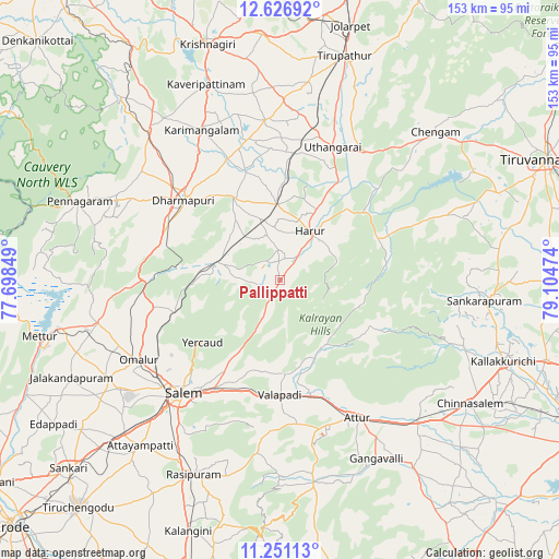
Pallippatti GPS coordinates[2]
11° 56' 23.64" North, 78° 24' 5.796" East
| Map corner | latitude | longitude |
|---|---|---|
| Upper-left | 12.62692°, | 77.69849° |
| Center: | 11.9399°, | 78.40161° |
| Lower-right: | 11.25113°, | 79.10474° |
| Map W x H: | 153×153 km | = 95.1×95.1mi |
| max Lat: | 34.9274° ⇑89.9% North |
| Pallippatti: | 11.9399° |
| min Lat: | ⇓10.1% South 8.09008° |
| min Long | Pallippatti | max Long |
| 68.82655° | 78.40161° | 96.81° |
| W 53.1%⇐ | ⇒46.9% E |
Elevation
Elevation of Pallippatti is 411 m = 1348 ft, and this is 115.4 m = 379 ft above average elevation for this country.
| Max E: |
3681 m = 12077 ft | 23.2% |
| Pallippatti | 411 m 1348 ft | |
| Avg. | 295.6 m = 970 ft | |
Min E: |
1 m = 3 ft | 76.8% |
See also: India elevation on elevation.city.
Geographical zone
Pallippatti is located in North Torrid zone (between Equator and Tropic of Cancer). Distance of this Northern Tropic circle is 1278.3 km =794.3 mi to North.| Distance of | km | miles | from Pallippatti |
|---|---|---|---|
| North Pole | 8679.5 | 5393.2 | to North |
| Arctic Circle | 6073.6 | 3774 | to North |
| Tropic Cancer | 1278.3 | 794.3 | to North |
| Equator | 1327.6 | 824.9 | to South |


Nearby cities:
15 places around Pallippatti: (largest is in red/bold)
• Attur
44.2 km =27.5 mi,  150°
150°
• Belūr
25.9 km =16.1 mi,  176°
176°
• Dharmapuri
33.7 km =20.9 mi,  308°
308°
• Gangavalli
56 km =34.8 mi, 151°
• Harūr
15.2 km =9.4 mi,  34°
34°
• Kunnattūr
46.9 km =29.1 mi,  14°
14°
• Mallāpuram
17.4 km =10.8 mi,  285°
285°
• Māllūr
52.4 km =32.6 mi,  212°
212°
• Nāmagiripettai
55.8 km =34.7 mi,  195°
195°
• Omalur
44.6 km =27.7 mi,  240°
240°
• Pālakkodu
54.4 km =33.8 mi,  318°
318°
• Pāpireddippatti
4.4 km =2.7 mi, 235°
• Pāppārappatti
48.6 km =30.2 mi, 310°
• Salem
41.6 km =25.8 mi,  220°
220°
• Tāramangalam
54.3 km =33.7 mi, 239°
Sources, notices
• [Note1] Compared only with cities in India existing in our database
• [Src1] Map data: © OpenStreetMap contributors (CC-BY-SA)
• [Src2] Other city data from geonames.org with taken over terms of usage.
• [Src3] Geographical zone / Annual Mean Temperature by Robert A. Rohde @ Wikipedia
