Kunnattūr geodata
Kunnattūr (Tamil Nadu) is a populated place; located in India in Asia/Kolkata (GMT+5.5) time zone. With population of 7,326 people, there are 3188 cities with bigger population in this country. Compared to other cities in India, 88.9% of cities are located further ↑North; 54.2% of cities are located further ←West and 73.1% of cities have lower elevation than Kunnattūr. Note1


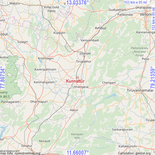
Kunnattūr GPS coordinates[2]
12° 20' 52.152" North, 78° 30' 37.656" East
| Map corner | latitude | longitude |
|---|---|---|
| Upper-left | 13.03376°, | 77.80734° |
| Center: | 12.34782°, | 78.51046° |
| Lower-right: | 11.66007°, | 79.21359° |
| Map W x H: | 152.7×152.7 km | = 94.9×94.9mi |
| max Lat: | 34.9274° ⇑88.9% North |
| Kunnattūr: | 12.34782° |
| min Lat: | ⇓11.1% South 8.09008° |
| min Long | Kunnattūr | max Long |
| 68.82655° | 78.51046° | 96.81° |
| W 54.2%⇐ | ⇒45.8% E |
Elevation
Elevation of Kunnattūr is 362 m = 1188 ft, and this is 66.4 m = 218 ft above average elevation for this country.
| Max E: |
3681 m = 12077 ft | 26.9% |
| Kunnattūr | 362 m 1188 ft | |
| Avg. | 295.6 m = 970 ft | |
Min E: |
1 m = 3 ft | 73.1% |
See also: India elevation on elevation.city.
Geographical zone
Kunnattūr is located in North Torrid zone (between Equator and Tropic of Cancer). Distance of this Northern Tropic circle is 1233 km =766.2 mi to North.| Distance of | km | miles | from Kunnattūr |
|---|---|---|---|
| North Pole | 8634.1 | 5365 | to North |
| Arctic Circle | 6028.2 | 3745.7 | to North |
| Tropic Cancer | 1233 | 766.2 | to North |
| Equator | 1372.9 | 853.1 | to South |


Nearby cities:
15 places around Kunnattūr: (largest is in red/bold)
• Alangāyam
40.2 km =25 mi,  40°
40°
• Ambur
54.2 km =33.7 mi,  24°
24°
• Chengam
30.8 km =19.1 mi,  98°
98°
• Dharmapuri
45.5 km =28.3 mi,  237°
237°
• Harūr
33 km =20.5 mi,  185°
185°
• Jalārpet
25.7 km =16 mi, 15°
• Krishnagiri
37.4 km =23.2 mi,  300°
300°
• Kuppam
48.2 km =30 mi,  337°
337°
• Kāveripatnam
32.7 km =20.3 mi,  284°
284°
• Mallāpuram
49.7 km =30.9 mi,  215°
215°
• Pallippatti
46.9 km =29.1 mi, 194°
• Pālakkodu
48 km =29.8 mi,  264°
264°
• Pāpireddippatti
50.2 km =31.2 mi,  197°
197°
• Pāppārappatti
51 km =31.7 mi,  253°
253°
• Vaniyambadi
39 km =24.2 mi, 17°
Sources, notices
• [Note1] Compared only with cities in India existing in our database
• [Src1] Map data: © OpenStreetMap contributors (CC-BY-SA)
• [Src2] Other city data from geonames.org with taken over terms of usage.
• [Src3] Geographical zone / Annual Mean Temperature by Robert A. Rohde @ Wikipedia
