Kelamangalam geodata
Kelamangalam (Tamil Nadu) is a populated place; located in India in Asia/Kolkata (GMT+5.5) time zone. With population of 11,328 people, there are 2801 cities with bigger population in this country. Compared to other cities in India, 88.2% of cities are located further ↑North; 53% of cities are located further →East and 94% of cities have lower elevation than Kelamangalam. Note1


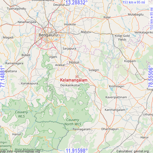
Kelamangalam GPS coordinates[2]
12° 36' 11.052" North, 77° 51' 6.948" East
| Map corner | latitude | longitude |
|---|---|---|
| Upper-left | 13.28832°, | 77.14881° |
| Center: | 12.60307°, | 77.85193° |
| Lower-right: | 11.91598°, | 78.55506° |
| Map W x H: | 152.6×152.6 km | = 94.8×94.8mi |
| max Lat: | 34.9274° ⇑88.2% North |
| Kelamangalam: | 12.60307° |
| min Lat: | ⇓11.8% South 8.09008° |
| min Long | Kelamangalam | max Long |
| 68.82655° | 77.85193° | 96.81° |
| W 47%⇐ | ⇒53% E |
Elevation
Elevation of Kelamangalam is 796 m = 2612 ft, and this is 500.4 m = 1642 ft above average elevation for this country.
| Max E: |
3681 m = 12077 ft | 6% |
| Kelamangalam | 796 m 2612 ft | |
| Avg. | 295.6 m = 970 ft | |
Min E: |
1 m = 3 ft | 94% |
See also: India elevation on elevation.city.
Geographical zone
Kelamangalam is located in North Torrid zone (between Equator and Tropic of Cancer). Distance of this Northern Tropic circle is 1204.6 km =748.5 mi to North.| Distance of | km | miles | from Kelamangalam |
|---|---|---|---|
| North Pole | 8605.7 | 5347.3 | to North |
| Arctic Circle | 5999.8 | 3728.1 | to North |
| Tropic Cancer | 1204.6 | 748.5 | to North |
| Equator | 1401.3 | 870.7 | to South |


Nearby cities:
15 places around Kelamangalam: (largest is in red/bold)
• Anekal
20.8 km =12.9 mi,  305°
305°
• Bengaluru
49.7 km =30.9 mi,  325°
325°
• Dasarahalli
55.2 km =34.3 mi,  357°
357°
• Denkanikota
10.6 km =6.6 mi,  220°
220°
• Hoskote
52.3 km =32.5 mi,  353°
353°
• Hosūr
15 km =9.3 mi, 351°
• Krishnagiri
40.4 km =25.1 mi,  103°
103°
• Kuppam
55.6 km =34.5 mi,  72°
72°
• Kānkānhalli
47.3 km =29.4 mi,  262°
262°
• Kāveripatnam
44.6 km =27.7 mi,  116°
116°
• Mālūr
45.5 km =28.3 mi,  11°
11°
• Mārāndahalli
29 km =18 mi,  145°
145°
• Pennāgaram
52.3 km =32.5 mi,  174°
174°
• Pālakkodu
40.6 km =25.2 mi,  144°
144°
• Pāppārappatti
48.1 km =29.9 mi, 152°
Sources, notices
• [Note1] Compared only with cities in India existing in our database
• [Src1] Map data: © OpenStreetMap contributors (CC-BY-SA)
• [Src2] Other city data from geonames.org with taken over terms of usage.
• [Src3] Geographical zone / Annual Mean Temperature by Robert A. Rohde @ Wikipedia
