Gohāna geodata
Gohāna (Haryana) is a populated place; located in India in Asia/Kolkata (GMT+5.5) time zone. With population of 56,093 people, there are 793 cities with bigger population in this country. Compared to other cities in India, 89.5% of cities are located further ↓South; 66.3% of cities are located further →East and 56.9% of cities have lower elevation than Gohāna. Note1


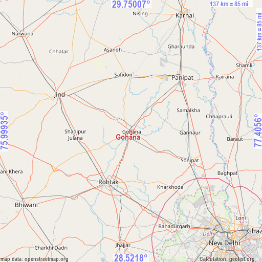
Gohāna GPS coordinates[2]
29° 8' 15.972" North, 76° 42' 8.892" East
| Map corner | latitude | longitude |
|---|---|---|
| Upper-left | 29.75007°, | 75.99935° |
| Center: | 29.13777°, | 76.70247° |
| Lower-right: | 28.5218°, | 77.4056° |
| Map W x H: | 136.6×136.6 km | = 84.9×84.9mi |
| max Lat: | 34.9274° ⇑10.5% North |
| Gohāna: | 29.13777° |
| min Lat: | ⇓89.5% South 8.09008° |
| min Long | Gohāna | max Long |
| 68.82655° | 76.70247° | 96.81° |
| W 33.7%⇐ | ⇒66.3% E |
Elevation
Elevation of Gohāna is 234 m = 768 ft, and this is 61.6 m = 202 ft below average elevation for this country.
| Max E: |
3681 m = 12077 ft | 43.1% |
| Avg. | 295.6 m = 970 ft | |
| Gohāna | 234 m = 768 ft | |
Min E: |
1 m = 3 ft | 56.9% |
See also: Gohāna elevation on elevation.city.
Geographical zone
Gohāna is located in North temperate zone (between Tropic of Cancer and the Arctic Circle). Distance of this Northern Tropic circle is 633.9 km =393.9 mi to South.| Distance of | km | miles | from Gohāna |
|---|---|---|---|
| North Pole | 6767.2 | 4204.9 | to North |
| Arctic Circle | 4161.4 | 2585.8 | to North |
| Tropic Cancer | 633.9 | 393.9 | to South |
| Equator | 3239.8 | 2013.1 | to South |


Nearby cities:
15 places around Gohāna: (largest is in red/bold)
• Bawāna
49.7 km =30.9 mi,  139°
139°
• Chhaprauli
46.5 km =28.9 mi,  80°
80°
• Jīnd
42.5 km =26.4 mi,  297°
297°
• Kalānaur
45.6 km =28.3 mi,  220°
220°
• Kharkhauda
35.2 km =21.9 mi, 144°
• Kheri Sāmpla
40.6 km =25.2 mi,  169°
169°
• Maham
43.8 km =27.2 mi,  244°
244°
• Narela
49.5 km =30.8 mi,  129°
129°
• Pānīpat
37.9 km =23.5 mi,  42°
42°
• Rohtak
29.2 km =18.1 mi,  202°
202°
• Safidon
30 km =18.6 mi,  354°
354°
• Samālkha
32 km =19.9 mi,  70°
70°
• Shādīpur Julāna
28.9 km =18 mi,  266°
266°
• Sonīpat
34.7 km =21.6 mi,  117°
117°
• Āsandh
43.7 km =27.2 mi, 347°
Sources, notices
• [Note1] Compared only with cities in India existing in our database
• [Src1] Map data: © OpenStreetMap contributors (CC-BY-SA)
• [Src2] Other city data from geonames.org with taken over terms of usage.
• [Src3] Geographical zone / Annual Mean Temperature by Robert A. Rohde @ Wikipedia
