Āsandh geodata
Āsandh (Haryana) is a populated place; located in India in Asia/Kolkata (GMT+5.5) time zone. With population of 25,323 people, there are 1678 cities with bigger population in this country. Compared to other cities in India, 91.2% of cities are located further ↓South; 67.2% of cities are located further →East and 58% of cities have lower elevation than Āsandh. Note1


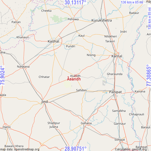
Āsandh GPS coordinates[2]
29° 31' 16.284" North, 76° 36' 19.872" East
| Map corner | latitude | longitude |
|---|---|---|
| Upper-left | 30.13117°, | 75.9024° |
| Center: | 29.52119°, | 76.60552° |
| Lower-right: | 28.90751°, | 77.30865° |
| Map W x H: | 136.1×136.1 km | = 84.6×84.6mi |
| max Lat: | 34.9274° ⇑8.8% North |
| Āsandh: | 29.52119° |
| min Lat: | ⇓91.2% South 8.09008° |
| min Long | Āsandh | max Long |
| 68.82655° | 76.60552° | 96.81° |
| W 32.8%⇐ | ⇒67.2% E |
Elevation
Elevation of Āsandh is 239 m = 784 ft, and this is 56.6 m = 186 ft below average elevation for this country.
| Max E: |
3681 m = 12077 ft | 42% |
| Avg. | 295.6 m = 970 ft | |
| Āsandh | 239 m = 784 ft | |
Min E: |
1 m = 3 ft | 58% |
See also: India elevation on elevation.city.
Geographical zone
Āsandh is located in North temperate zone (between Tropic of Cancer and the Arctic Circle). Distance of this Northern Tropic circle is 676.5 km =420.4 mi to South.| Distance of | km | miles | from Āsandh |
|---|---|---|---|
| North Pole | 6724.6 | 4178.5 | to North |
| Arctic Circle | 4118.7 | 2559.2 | to North |
| Tropic Cancer | 676.5 | 420.4 | to South |
| Equator | 3282.4 | 2039.6 | to South |


Nearby cities:
15 places around Āsandh: (largest is in red/bold)
• Bara Uchāna
41.8 km =26 mi,  261°
261°
• Gharaunda
35.4 km =22 mi,  87°
87°
• Gohāna
43.7 km =27.2 mi,  167°
167°
• Jīnd
36.2 km =22.5 mi,  230°
230°
• Kaithal
37 km =23 mi,  327°
327°
• Karnāl
41.3 km =25.7 mi,  62°
62°
• Narwāna
47.8 km =29.7 mi,  280°
280°
• Nīlokheri
47.2 km =29.3 mi,  41°
41°
• Pehowa
50.9 km =31.6 mi,  357°
357°
• Pānīpat
38.1 km =23.7 mi,  112°
112°
• Pūndri
27 km =16.8 mi,  350°
350°
• Safidon
14.3 km =8.9 mi,  153°
153°
• Samālkha
50.7 km =31.5 mi,  128°
128°
• Shādīpur Julāna
48.3 km =30 mi,  203°
203°
• Thānesar
54.8 km =34.1 mi,  23°
23°
Sources, notices
• [Note1] Compared only with cities in India existing in our database
• [Src1] Map data: © OpenStreetMap contributors (CC-BY-SA)
• [Src2] Other city data from geonames.org with taken over terms of usage.
• [Src3] Geographical zone / Annual Mean Temperature by Robert A. Rohde @ Wikipedia
